- Joined
- Jun 27, 2024
- Messages
- 2,998
- Likes
- 10,709
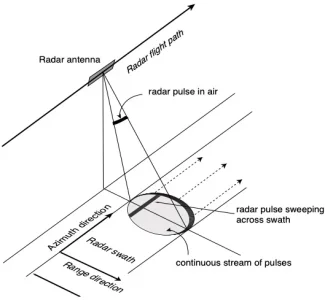
The basic principle of any imaging radar is to emit an electromagnetic signal (which travels at the speed of light) toward a surface and record the amount of signal that bounces/echoes back, or “backscatters,” and its time delay. The resulting radar imagery is built up from the strength and time delay of the returned signal, which depends primarily on the roughness and electrical conducting properties of the observed surface and its distance from the orbiting radar.
SAR techniques take advantage of the fact that the radar is moving in orbit to synthesize a virtual 10-km-long antenna from the physical 10-m antenna in the direction of flight. As the radar moves along its path, it sweeps the antenna’s footprint across the ground while continuously transmitting pulses – short signal bursts separated by time – and receiving the echoes of the returned pulses.
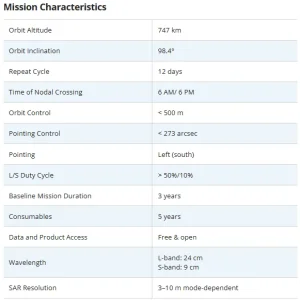
NASA-ISRO SAR (NISAR) is a Low Earth Orbit (LEO) observatory being jointly developed by NASA and ISRO. NISAR will map the entire globe in 12 days and provide spatially and temporally consistent data for understanding changes in Earth’s ecosystems, ice mass, vegetation biomass, sea level rise, ground water and natural hazards including earthquakes, tsunamis, volcanoes and landslides. NISAR. It carries L and S dual band Synthetic Aperture Radar (SAR), which operates with Sweep SAR technique to achieve large swath with high resolution data. The SAR payloads mounted on Integrated Radar Instrument Structure (IRIS) and the spacecraft bus are together called an observatory. Jet Propulsion Laboratories and ISRO are realizing the observatory which shall not only meet the respective national needs but also will feed the science community with data encouraging studies related to surface deformation measurements through repeat-pass InSAR technique.
This flagship partnership would have major contributions from both agencies. NASA is responsible for providing the L-Band SAR payload system in which the ISRO supplied S-Band SAR payload and both these SAR systems will make use of a large size (about 12m diameter) common unfurl able reflector antenna . In addition, NASA would provide engineering payloads for the mission, including a Payload Data Subsystem, High-rate Science Downlink System, GPS receivers and a Solid State
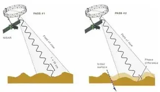
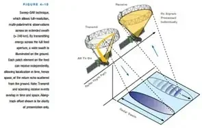
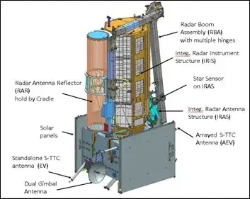
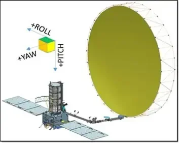
The NISAR observatory carries a 12m wide deployable mesh reflector mounted onto a deployable 9m boom developed by JPL which shall be used by both-JPL-NASA developed L-Band SAR payload system and ISRO developed S-Band SAR payload. The IRIS hosts the S-SAR and L-SAR tiles along with their electronics and data handling systems. The spacecraft incorporates all the attitude and orbit control elements, power systems, thermal management system. JPL also will provide the LSAR Data Handling system, High-rate Science data Downlink System, GPS receivers and a Solid State Recorder. ISRO is responsible for providing the SSAR data handling system, High rate downlink system, spacecraft bus systems, the GSLV launch system and Mission Operations Related Services. A perfect blend of two cultures and a creation by two sets of craftsmen is what NISAR is.
COMMISSIONING PHASEThe NISAR Observatory will be launched from Satish Dhawan Space Centre(SDSC) SHAR, Sriharikota on the southeast coast of the Indian peninsula, on the GSLV expendable launch vehicle contributed by ISRO. The target launch readiness date is January 2024. The launch sequence encompasses the time interval that takes the observatory from the ground, encapsulated in the launch vehicle fairing, to after separation, and ends with the completion of solar array deployment and the observatory in an Earth-pointed attitude and in two-way communication with the ground. The launch sequence is a critical event.
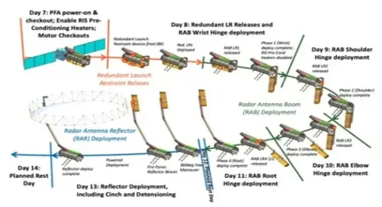
SCIENCE OPERATIONS PHASEThe first 90 days after launch will be dedicated to commissioning, or in-orbit checkout (IOC), the objective of which is to prepare the observatory for science operations. Commissioning is divided into sub-phases of initial checkout (ISRO engineering systems and JPL engineering payload checkout), spacecraft checkout and instrument checkout. Philosophically, the sub-phases are designed as a step-by-step build up in capability to full observatory operations, beginning with the physical deployment of all deployable parts (notably the boom and radar antenna, but not including the solar arrays which are deployed during launch phase), checking out the engineering systems, turning on the radars and testing them independently and then conducting joint tests with both radars operating.
The science operations phase begins at the end of commissioning and extends for three years and contains all data collection required to achieve the L1 science objectives. During this phase, the science orbit will be maintained via regular maneuvers, scheduled to avoid or minimize conflicts with science observations. Extensive calibration and validation (CalVal) activities will take place throughout the first 5 months, with yearly updates of 1-month duration. The observation plan for both L- and S-band instruments, along with engineering activities (e.g., maneuvers, parameter updates, etc.), will be generated pre-launch via frequent coordination between JPL and ISRO. This plan is called the reference mission; the science observations alone within that reference mission is called the reference observation plan (ROP). The schedule of science observations will be driven by a variety of inputs, including L- and S-band target maps, radar mode tables, and spacecraft and ground-station constraints and capabilities. This schedule will be determined by JPL’s mission planning team, and the project will endeavour to fly the reference mission, which includes these science observations exactly as planned pre-launch (accommodating for small timing changes based on the actual orbit).
ISRO offers the NISAR Utilization Programme (NISAR UP), an opportunity for Indian researchers and scientists to access, analyse and interpret the data from the NASA–ISRO Synthetic Aperture Radar (NISAR) satellite mission.
NISAR offers vital data to observe and study Earth’s intricate processes. This cutting-edge mission involves high-resolution imaging, wide swath, precise orbit control, and short revisit periods. It aims to study ecosystems, cryosphere, solid earth science, and coastal ocean processes to address global environmental changes and natural hazards. It supports disaster response by providing rapid access to relevant data.
NISAR UP seeks project proposals from researchers, academicians, and scientists affiliated with Indian Government organizations and Government-recognized institutions, universities, and departments. The programme, offered by the Space Applications Centre (SAC)/ISRO, looks to support 3-year projects, through an open data policy, in diverse application themes, such as agriculture, forestry, hydrology, snow/glaciers, disaster management, and more, using the L & S-band SAR data from NISAR.
The focus areas include developing operational algorithms for applications in different fields, retrieval of biogeophysical parameters using NISAR and ancillary data, calibration/validation of NISAR data/science, tool development for NISAR data analysis, and value-added products/services to cater to user requirements. Selected projects will receive funding support, while non-funded projects will have access to technical support and ground validation data provided by ISRO.
Mission details, guidelines, and proposal submission formats are at here. Project proposals may be submitted by October 31, 2023. Evaluation results will be communicated by March 01, 2024.
The researchers are invited to join the Programme, leveraging NISAR data to make discoveries and create a sustainable future for our planet.
