ISRO - General Discussions

Mail-SPL-468-X60-2x

Aircraft GPS system stalls before takeoff​

Developed at a cost of Rs 774 crore, GAGAN is a satellite-based aviation navigation system.


Sanjay Singh


Updated on:
22 Jan 2017, 1:57 pm

2 min read

Follow Us
NEW DELHI: After Indian carriers’ reluctance to install India’s indigenous GPS Aided Geo Augmented Navigation system (GAGAN) on their aircraft, the government has started using it for non-aviation purposes. Private airlines’ refusal is due to the Rs 1.25 crore required to install GAGAN and extra costs to train pilots on how to use it. Airlines prefer using globally approved navigational devices.
TNIE%2Fimport%2Fuploads%2Fuser%2Fckeditor_images%2Farticle%2F2017%2F1%2F22%2FAircraft.jpg


Developed at a cost of Rs 774 crore, GAGAN is a satellite-based aviation navigation system. It has been lying defunct since 2013. India’s aviation regulator, the Directorate General of Civil Aviation (DGCA), is also helpless in making airlines install GAGAN despite the New Civil Aviation Policy (NCAP) asking airlines to do so.
A senior DGCA official said that airlines cannot be forced to install GAGAN on their aircraft, and to make that happen, there would be a need to amend DGCA rules.
Airports Authority of India (AAI) is now tying up with non-aviation agencies to use GAGAN for disaster management, monitoring of tides and waves in oceans besides surveillance services required by agencies to collect data. AAI’s executive director S V Satish said international airlines body International Civil Aviation Organisation has called for using globally accepted air navigation systems.
Since late 2014, domestic carriers have added over 130 narrow and wide bodied planes in their fleet, but not a single airline has installed GAGAN. Indian carriers use the GPS-based air navigation system using GPS-GNSS receivers for air navigation purposes and operational use, which is used globally by airlines.
The Narendra Modi government had termed the project as one of its achievements.
 

View: https://www.youtube.com/live/-jcCZl7RJZ8?feature=shared&t=5479

although it is still not operationalized by airport authority of India due to various reason but now all new aircrafts are fitted with the GAGAN receivers and the old aircrafts are getting now retrofitted with these GAGAN receivers. So that whenever aircraft move from one place to another and all aircraft movement mostly are all international movement from not only within the country but outside the country also. So the same receiver should seamlessly work with the satellites of India also.

This is latest update
 
Last edited:

View: https://www.youtube.com/live/-jcCZl7RJZ8?feature=shared&t=5479

although it is still not operationalized by airport authority of India due to various reason but now all new aircrafts are fitted with the GAGAN receivers and the old aircrafts are getting now retrofitted with these GAGAN receivers. So that whenever aircraft move from one place to another and all aircraft movement mostly are all international movement from not only within the country but outside the country also. So the same receiver should seamlessly work with the satellites of India also.

This is latest update

01:33:32
satellite is needed but we are active satellite and one standby. So one will work as a standby in space. Two parallel channels will be provided to any receiver working on ground or in aircraft and that will be utilized to provide the navigation services to the pilot who will utilize this to go for safe landing. So we have already got certification as far as end route and precision approach is concerned and now landing and takeoff related these things are pending
1749616019723.webp
 
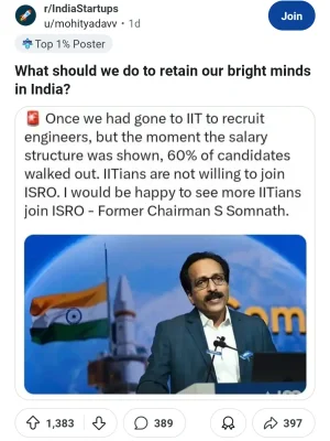
This old comment making rounds in internet . Isn't 80k/90k in-hand as a fresher good enough .. You get your govt quarters with your own area which ll cost 50k rent in metro cities . Job security and further a good looking wife/ husband is a addition 😁 .. Now there ll be 8th pay comission and more increament .

Screenshot_2025-06-11-10-52-51-77_b72a20be883aec8a014bd2b7c7038e87.webp

But I definitely agree that experienced people who enter lateral , who can add value must be paid as per their worth . Flexibility in pay is indeed a issue in govt sector .. The reason private sector around the world excell in talent retention and innovation.
 
01:33:32
satellite is needed but we are active satellite and one standby. So one will work as a standby in space. Two parallel channels will be provided to any receiver working on ground or in aircraft and that will be utilized to provide the navigation services to the pilot who will utilize this to go for safe landing. So we have already got certification as far as end route and precision approach is concerned and now landing and takeoff related these things are pending
View attachment 38979

View: https://www.youtube.com/watch?v=-jcCZl7RJZ8&t=1h31m20s
 
@54:26
if you see presently we are working on all these frequencies currently we have already moved to this KU and carbon high throughput satellites and we are now building very large satellites of weight 4,000 to up to 6,000 kg and from power of 1.5 kilowatt to up to 15 kilowatt so this is where we are today and in future as I said we are moving to Q and V band we are moving to optical frequency band and now we are moving from geo orbit these are all geocatellates or third satellite at the height of 36,000 kilometer where they appear stationary with respect to earth and from there they will move on to now what we call the LEO and the MEO satellite
 
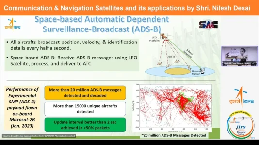
@59:20 we have made a experimental payload for spectrum monitoring payload which is also has it use in electric electronic or signal intelligence activity as well as we will be using it to monitor the air traffic. So we use satellite to monitor the movement of various aircraft all across the country in the Indian FIR region. So that is how the spectrum monitoring payload has been demonstrated and now we are looking forward to a full-fledged constellation of ADSB type of network which will do the regular monitoring of all the aircraft all across the country. the tasks which are right now performed through ATC's that is localized way
1749625870495.webp
 
Last edited:
@1:05:21
now we are on to a future satellite which we are building first as a technology demonstrator satellite TDS1 and TDS2 and after that we'll move to the operational satellite
 
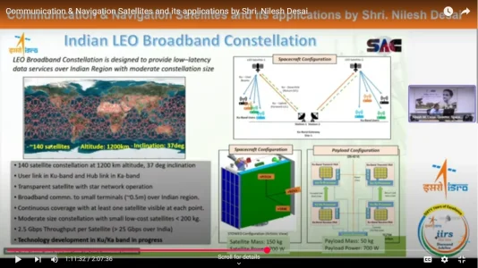
@1:11:24 Screenshot 2025-06-11 125059.webpWe have also worked out constellation of around 140 satellite. Of course, it will not take care of whole India but almost 60 70% of the urban area coverage is taken care of by this constellation. It will operate at around 1200 kilometers. So we are looking government is now looking forward to a PPP mode implementation of this particular configuration where jointly government and private sector will build this 140 satellite and which will provide the starling type of services for our own country. Of course, once you have leo orbiting satellite, it can provide services any anywhere across the world.
 
@1:16:21
We are also working with IIT Hyderabad uh using that chip which we they developed what we call NB IoT waveform ORScreenshot 2025-06-11 130906.webp narrowand IoT waveform which will be have a common heritage all across the terrestrial network as well as the satellite network
 
Screenshot 2025-06-11 132328.webp
@1:21:45
ABOUT GSAT 29 OPTICAL COMUNNICATION LINK
we are still struggling to establish the communication channel. Although we could locate the satellite, we could establish the link between ground station and the satellite but we are not able to transmit data because of some technical issues which are there on the onboard setter. So now we cannot repair it also. So we are just trying to see doing various experiment for ground to satellite satellite to satellite type of different type of communication data transmission. So this was the precursor the first development of optical link
 
Screenshot 2025-06-11 133359.webp
@1:41:49
Now these mobiles which I have listed Zomi M18, MI9, V20, Okonor, Oppo 10, Xoom, Lenovo 26 all these now contain Navi and there is a rule in countries like Russia and China that if you are in that country you have to necessarily use their navigation system. Unlike that uh in India we have not made that rule but tomorrow it may come also anytime once we are operationalizing our nav system. So you can use GPS but in Russia or China also but your mobile has to be PU enabled or LONAS enabled. Similarly our mobile in India should be Navic enabled that is going to come in future. So we tested this our receivers all across the country different places even we provided it to our military
 
Screenshot 2025-06-11 134140.webp
 
Screenshot 2025-06-11 134941.webp
I ONCE mentioned about moon data reley sate which enable china to communicate from far side of moon seems like our own is lunar inter plantery navingation sat is proposed
@1:56:20
So this is another area of research as far as scientists are concerned. So lunar pnt where on moon we'll use navigation system we launch satellite around moon which will provide like GPS is providing or nav is providing services on earth similarly there will be dedicated navigation satellite providing services on moon similarly we have now riost is already going to happen through private sector and underwater navigation for submarines and many other underwater vehicles will also be required for use for many military purpose. And this is what lunar pnt is what I was mentioning that we'll use the backlog of the earth system like mavic or GPS to find out the position of the spacecraft while it is going towards moon or toward Mars or we can use the dedicated satellite around the moon which will each country will uh launch one one satellites. So NASA will launch one, Europeans will launch one, Japanese space agency will launch one, india will launch one satellite
 
VPN-HSL-468-X60-2x

Latest Replies

Featured Content

Trending Threads

Back
Top