General History Thread - India : News , Updates & Discussions .

Mail-SPL-468-X60-2x
come from outside? We keep calling them Indo-Uropean or Indoarian languages. But that's wrong. They are not Indo-arian at all but simply Vic language. Language that spread outwards from the Saraswati civilization. Sanskrit emerged here alongside the Vic rituals and hence then how did it suddenly become a foreign import? It didn't. We then inherit Sanskrit. We exported it. And all those so-called Indoarian connections we see in Persia, Europe and beyond. They aren't coincidences. They're echoes of a


08:21
civilization that once thrived along the Saraswat and then spread it language, its culture, its gods and its stories to rest of the world. Now if you want to know more about how these connections were formed from the Yadus in the Matura to the Pakun in Afghanistan, go watch my previous video on RV theory because Saraswati is the missing link, the proof that Vic civilization wasn't isolated. It was a launchpad that carried out culture across the ancient world. When I started researching Saraswati, it


08:53
quickly became clear this wasn't just a river. It was a timeline. Geologist studied the Gaga Talio channel, now identified as Saraswati. Their findings, the riverbed dates back to over 200,000 years, long before modern humans even existed. But I wasn't looking for rocks. I was looking for people. Studies by CSIR, NGRI, IIT, Kpur, ISRO and Bach confirmed that this river carried glacial melt from the Himalayas until around 4,000 BC. But there is more. Dr. Rajes Shangi and Chamayal pushed the timeline further. Saraspati was
09:34
flourishing around 10,000 BC, maybe even earlier. That's long before Egypt, Sumere, or Mesopotamia. And it explains that why we find over 90 archaeological sites along her banks. Rakiari, Birana, Kalibangan, Banavali all showing signs of city planning, fire alters, water management and early script. And that's just what we can see. According to archaeologist Disha Aluualia, hundreds of sites remain buried, hidden beneath towns in Punjab, Hana, and Rajasthan. What we have uncovered so far, it's barely 10% of what could still be out


10:14
there. A river once dismissed as a myth may hold the key to a civilization older than anything we have been taught. If Sarasati was thriving around 10,000 BC, then the Vic civilization was too. And if that's true, we need to ask how far back does Bharat really go? Because while geology help us trace Sarasati's body, astronomy helps us understand its soul. The people who looked up at the stars and wrote them into the hymns. The rigid isn't just spiritual poetry. It holds some of the most
precise sky

10:55
references in any ancient text describing planetary alignments, solstice, eclipses. Modern astronomers have simulated those patterns and many match the skies of 10,000 BC. Take the work of TPMA and PVA who analyze the sky positions described in Vic verses. Some of them like the threat brahmana's reference to star Ajakpada purva rising due east only happened around 10,000 BC. It hasn't repeated since. The Shhatpata Brahmana mentions Kitika the Plleades rising in the east a detail that places the text around 30,000 BC and then


11:41
there's the Mahabharat in the Sabaparva the position of Saturn Mars Jupiter Venus and lunar eclipse are described in astonishing details based on that researchers like Dr. Wartak and Nilles calculated the timing of the Kurukhetra war to around 5561 BC. Even the Ramayana includes a moment when Ram is born under a rare alignment. Five planets exalted in their own signs. Multiple simulations place this around 12,000 BC. Now ask yourself, were these just poetic metaphors or actual memories of the sky recorded by


12:22
people who were there to witness it? Because astronomy doesn't lie. And when multiple ancient text written centuries apart describe alignments that match prehistoric sky patterns, it can't be a coincidence. Now, let's tie this back to Saraswati. When we line up the geological data with the astronomical references, the glacier Fred Gagrahawk from 12,000 to 7,500 BC, the rigidic hymns describing star positions from 10,000 BC. Everything aligns. The people who composed these hymns, they weren't nomads. They were astronomers, builders,
13:01
priest, a civilization grounded in science, ritual, and memory. And that's where most historians got it wrong. They confused the date of writing with the date of origin. Because the Vedas weren't written first. They were remembered, chanted, and passed down perfectly preserved word for word for millennia. No manuscripts, no monuments, just memory. But the west didn't understand that. So they measured us by what they could dig up. Stone, clay, inscriptions. But the Vic civilization, it wasn't written in stone. It was


13:38
etched in consciousness. That's why Saraswati was erased. Not because she didn't exist, but because her existence shattered the timeline. It forced a rewrite of world history. Placing Bat not the west as the cradle of civilization. But even if the river vanished, her memory remained in the verses, in the ruins, in us. We have just scratched the surface of what it really means when we say that Saraswati was real. This video was about proving her existence and exposing the conspiracy behind bearing it. But this


14:15
is just the beginning. We have already explored Vic connection with other civilizations from the Mayans to Persia, from Turkey to Nazca and all the way to America. But there's so much more. And now I need your support. Subscribe if you want to go deeper. Comment below which civilizational connection you would like to explore next. Egypt, Sumere. But at the end of the day, they were all connected by one thread, Sanatan Dharma. The universal principle of living. This is it from my side. This is Harry signing off. Stay curious.
 
1.webp2.webp3.webp4.webp
 
Last edited:
Jasjeet Kaur, Gurvinder S. Sodhi andRitika Sayal
During the ancient era, the Indians, Chinese, Japanese and Arg-
entinians had a fairly good knowledge of thescience of fingerp-
rinting. However, the oldest documents on this subject are found
in India and Argentina, andprobably, this discipline evolved con-
temporaneously in these two countries. Indians were not only
aware of theimportance of this discipline but were also quite
passionate about taking it to great heights. This passionbro-
ught about the metamorphosis of fingerprinting from a mere cur-
iosity stage to a more sophisticated stage,replacing all other
trivial identification systems. This note traces the evolution of
fingerprint identificationfrom the ancient era through the medi-
eval era to the modern era of Indian history.
 
Telegraphic code for fingerprints: How justice was denied to the innovator
who helped ameliorate the criminal justice system
 

Attachments

The Colonial Legacy - Myths and Popular Beliefs

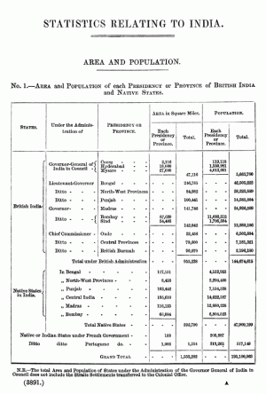
While few educated South Asians would deny that British Colonial rule was detrimental to the interests of the common people of the sub-continent - several harbor an illusion that the British weren't all bad. Didn't they, perhaps, educate us - build us modern cities, build us irrigation canals - protect our ancient monuments - etc. etc. And then, there are some who might even say that their record was actually superior to that of independent India's! Perhaps, it is time that the colonial record be retrieved from the archives and re-examined - so that those of us who weren't alive during the freedom movement can learn to distinguish between the myths and the reality.

Literacy and Education

Several Indians are deeply concerned about why literacy rates in India are still so low. So in the last year, I have been making a point of asking English-speaking Indians to guess what India's literacy rate in the colonial period might have been. These were Indians who went to school in the sixties and seventies (only two decades after independence) - and I was amazed to hear their fairly confident guesses. Most guessed the number to be between 30% and 40%. When I suggested that their guess was on the high side - they offered 25% to 35%. No one was prepared to believe that literacy in British India in 1911 was only 6%, in 1931 it was 8%, and by 1947 it had crawled to 11%! That fifty years of freedom had allowed the nation to quintuple it's literacy rate was something that almost seemed unfathomable to them. Perhaps - the British had concentrated on higher education ....? But in 1935, only 4 in 10,000 were enrolled in universities or higher educational institutes. In a nation of then over 350 million people only 16,000 books (no circulation figures) were published in that year (i.e. 1 per 20,000).

Urban Development

It is undoubtedly true that the British built modern cities with modern conveniences for their administrative officers. But it should be noted that these were exclusive zones not intended for the "natives" to enjoy. Consider that in 1911, 69 per cent of Bombay's population lived in one-room tenements (as against 6 per cent in London in the same year). The 1931 census revealed that the figure had increased to 74 per cent - with one-third living more than 5 to a room. The same was true of Karachi and Ahmedabad. After the Second World War, 13 per cent of Bombay's population slept on the streets. As for sanitation, 10-15 tenements typically shared one water tap!

Yet, in 1757 (the year of the Plassey defeat), Clive of the East India Company had observed of Murshidabad in Bengal: "This city is as extensive, populous and rich as the city of London..." (so quoted in the Indian Industrial Commission Report of 1916-18). Dacca was even more famous as a manufacturing town, it's muslin a source of many legends and it's weavers had an international reputation that was unmatched in the medieval world. But in 1840 it was reported by Sir Charles Trevelyan to a parliamentary enquiry that Dacca's population had fallen from 150,000 to 20,000. Montgomery Martin - an early historian of the British Empire observed that Surat and Murshidabad had suffered a similiar fate. (This phenomenon was to be replicated all over India - particularly in Awadh (modern U.P) and other areas that had offered the most heroic resistance to the British during the revolt of 1857.)

The percentage of population dependant on agriculture and pastoral pursuits actually rose to 73% in 1921 from 61% in 1891. (Reliable figures for earlier periods are not available.)

In 1854, Sir Arthur Cotton writing in "Public Works in India" noted: "Public works have been almost entirely neglected throughout India... The motto hitherto has been: 'Do nothing, have nothing done, let nobody do anything....." Adding that the Company was unconcerned if people died of famine, or if they lacked roads and water.

Nothing can be more revealing than the remark by John Bright in the House of Commons on June 24, 1858, "The single city of Manchester, in the supply of its inhabitants with the single article of water, has spent a larger sum of money than the East India Company has spent in the fourteen years from 1834 to 1848 in public works of every kind throughout the whole of its vast dominions.
Irrigation and Agricultural Development

There is another popular belief about British rule: 'The British modernized Indian agriculture by building canals'. But the actual record reveals a somewhat different story. " The roads and tanks and canals," noted an observer in 1838 (G. Thompson, "India and the Colonies," 1838), ''which Hindu or Mussulman Governments constructed for the service of the nations and the good of the country have been suffered to fall into dilapidation; and now the want of the means of irrigation causes famines." Montgomery Martin, in his standard work "The Indian Empire", in 1858, noted that the old East India Company "omitted not only to initiate improvements, but even to keep in repair the old works upon which the revenue depended."

The Report of the Bengal Irrigation Department Committee in 1930 reads: "In every district the Khals (canals) which carry the internal boat traffic become from time to time blocked up with silt. Its Khals and rivers are the roads end highways of Eastern Bengal, and it is impossible to overestimate the importance to the economic life of this part of the province of maintaining these in proper navigable order ....... " "As regards the revival or maintenance of minor routes, ... practically nothing has been done, with the result that, in some parts of the Province at least, channels have been silted up, navigation has become limited to a few months in the year, and crops can only be marketed when the Khals rise high enough in the monsoon to make transport possible".

Sir William Willcock, a distinguished hydraulic engineer, whose name was associated with irrigation enterprises in Egypt and Mesopotamia had made an investigation of conditions in Bengal. He had discovered that innumerable small destructive rivers of the delta region, constantly changing their course, were originally canals which under the English regime were allowed to escape from their channels and run wild. Formerly these canals distributed the flood waters of the Ganges and provided for proper drainage of the land, undoubtedly accounting for that prosperity of Bengal which lured the rapacious East India merchants there in the early days of the eighteenth century.. He wrote" Not only was nothing done to utilize and improve the original canal system, but railway embankments were subsequently thrown up, entirely destroying it. Some areas, cut off from the supply of loam-bearing Ganges water, have gradually become sterile and unproductive, others improperly drained, show an advanced degree of water-logging, with the inevitable accompaniment of malaria. Nor has any attempt been made to construct proper embankments for the Gauges in its low course, to prevent the enormous erosion by which villages and groves and cultivated fields are swallowed up each year."

"Sir William Willcock severely criticizes the modern administrators and officials, who, with every opportunity to call in expert technical assistance, have hitherto done nothing to remedy this disastrous situation, from decade to decade." Thus wrote G. Emerson in "Voiceless Millions," in 1931 quoting the views of Sir William Willcock in his "Lectures on the Ancient System of Irrigation in Bengal and its Application to Modern Problems" (Calcutta University Readership Lectures, University of Calcutta, 1930)

Modern Medicine and Life Expectancy

Even some serious critics of colonial rule grudgingly grant that the British brought modern medicine to India. Yet - all the statistical indicators show that access to modern medicine was severely restricted. A 1938 report by the ILO (International Labor Office) on "Industrial Labor in India" revealed that life expectancy in India was barely 25 years in 1921 (compared to 55 for England) and had actually fallen to 23 in 1931! In his recently published "Late Victorian Holocausts" Mike Davis reports that life expectancy fell by 20% between 1872 and 1921.

In 1934, there was one hospital bed for 3800 people in British India and this figure included hospital beds reserved for the British rulers. (In that same year, in the Soviet Union, there were ten times as many.) Infant mortality in Bombay was 255 per thousand in 1928. (In the same year, it was less than half that in Moscow.)

Poverty and Population Growth

Several Indians when confronted with such data from the colonial period argue that the British should not be specially targeted because India's problems of poverty pre-date colonial rule, and in any case, were exacerbated by rapid population growth. Of course, no one who makes the first point is able to offer any substantive proof that such conditions prevailed long before the British arrived, and to counter such an argument would be difficult in the absence of reliable and comparable statistical data from earlier centuries. But some readers may find the anecdotal evidence intriguing. In any case, the population growth data is available and is quite remarkable in what it reveals.

Between 1870 and 1910, India's population grew at an average rate of 19%. England and Wales' population grew three times as fast - by 58%! Average population growth in Europe was 45%. Between 1921-40, the population in India grew faster at 21% but was still less than the 24% growth of population in the US!

In 1941, the density of population in India was roughly 250 per square mile almost a third of England's 700 per square mile. Although Bengal was much more densely inhabited at almost 780 per square mile - that was only about 10% more than England. Yet, there was much more poverty in British India than in England and an unprecedented number of famines were recorded during the period of British rule.

Not surprising, since the export of food grains had increased by a factor of four just prior to that period. And export of other agricultural raw materials had also increased in similar proportions. Land that once produced grain for local consumption was now taken over by by former slave-owners from N. America who were permitted to set up plantations for the cultivation of lucrative cash crops exclusively for export. Particularly galling is how the British colonial rulers continued to export foodgrains from India to Britain even during famine years.

Annual British Government reports repeatedly published data that showed 70-80% of Indians were living on the margin of subsistence. That two-thirds were undernourished, and in Bengal, nearly four-fifths were undernourished.

Contrast this data with the following accounts of Indian life prior to colonization:-

" ....even in the smallest villages rice, flour, butter, milk, beans and other vegetables, sugar and sweetmeats can be procured in abundance .... Tavernier writing in the 17th century in his "Travels in India".

Manouchi - the Venetian who became chief physician to Aurangzeb (also in the 17th century) wrote: "Bengal is of all the kingdoms of the Moghul, best known in France..... We may venture to say it is not inferior in anything to Egypt - and that it even exceeds that kingdom in its products of silks, cottons, sugar, and indigo. All things are in great plenty here, fruits, pulse, grain, muslins, cloths of gold and silk..."

The French traveller, Bernier also described 17th century Bengal in a similiar vein: "The knowledge I have acquired of Bengal in two visits inclines me to believe that it is richer than Egypt. It exports in abundance cottons and silks, rice, sugar and butter. It produces amply for it's own consumption of wheat, vegetables, grains, fowls, ducks and geese. It has immense herds of pigs and flocks of sheep and goats. Fish of every kind it has in profusion. From Rajmahal to the sea is an endless number of canals, cut in bygone ages from the Ganges by immense labour for navigation and irrigation."

The poverty of British India stood in stark contrast to these eye witness reports and has to be ascribed to the pitiful wages that working people in India received in that period. A 1927-28 report noted that "all but the most highly skilled workmen in India receive wages which are barely sufficient to feed and clothe them. Everywhere will be seen overcrowding, dirt and squalid misery..."

This in spite of the fact that in 1922 - an 11 hour day was the norm (as opposed to an 8 hour day in the Soviet Union.) In 1934, it had been reduced to 10 hours (whereas in the Soviet Union, the 7 hour day had been legislated as early as in 1927) What was worse, there were no enforced restrictions on the use of child labour and the Whitley Report found children as young as five - working a 12 hour day.

Ancient Monuments

Perhaps the least known aspect of the colonial legacy is the early British attitude towards India's historic monuments and the extend of vandalism that took place. Instead, there is this pervasive myth of the Britisher as an unbiased "protector of the nation's historic legacy".

R.Nath in his 'History of Decorative Art in Mughal Architecture' records that scores of gardens, tombs and palaces that once adorned the suburbs of Sikandra at Agra were sold out or auctioned. "Relics of the glorious age of the Mughals were either destroyed or converted beyond recognition..". "Out of 270 beautiful monuments which existed at Agra alone, before its capture by Lake in 1803, hardly 40 have survived".

In the same vein, David Carroll (in 'Taj Mahal') observes: " The forts in Agra and Delhi were commandeered at the beginning of the nineteenth century and turned into military garrisons. Marble reliefs were torn down, gardens were trampled, and lines of ugly barracks, still standing today, were installed in their stead. In the Delhi fort, the Hall of Public Audience was made into an arsenal and the arches of the outer colonnades were bricked over or replaced with rectangular wooden windows."

The Mughal fort at Allahabad (one of Akbar's favorite) experienced a fate far worse. Virtually nothing of architectural significance is to be seen in the barracks that now make up the fort. The Deccan fort at Ahmednagar was also converted into barracks. Now, only its outer walls can hint at its former magnificence.

Shockingly, even the Taj Mahal was not spared. David Carroll reports: "..By the nineteenth century, its grounds were a favorite trysting place for young Englishmen and their ladies. Open-air balls were held on the marble terrace in front of the main door, and there, beneath Shah Jahan"s lotus dome, brass bands um-pah-pahed and lords and ladies danced the quadrille. The minarets became a popular site for suicide leaps, and the mosques on either side of the Taj were rented out as bungalows to honeymooners. The gardens of the Taj were especially popular for open-air frolics....."

"At an earlier date, when picnic parties were held in the garden of the Taj, related Lord Curzon, a governor general in the early twentieth century, "it was not an uncommon thing for the revellers to arm themselves with hammer and chisel, with which they wiled away the afternoon by chipping out fragments of agate and carnelian from the cenotaphs of the Emperor and his lamented Queen." The Taj became a place where one could drink in private, and its parks were often strewn with the figures of inebriated British soldiers.

Lord William Bentinck, (governor general of Bengal 1828-33, and later first governor general of all India), went so far as to announce plans to demolish the best Mogul monuments in Agra and Delhi and remove their marble facades. These were to be shipped to London, where they would be broken up and sold to members of the British aristocracy. Several of Shahjahan's pavilions in the Red Fort at Delhi were indeed stripped to the brick, and the marble was shipped off to England (part of this shipment included pieces for King George IV himself). Plans to dismantle the Taj Mahal were in place, and wrecking machinery was moved into the garden grounds. Just as the demolition work was to begin, news from London indicated that the first auction had not been a success, and that all further sales were cancelled -- it would not be worth the money to tear down the Taj Mahal.

Thus the Taj Mahal was spared, and so too, was the reputation of the British as "Protectors of India's Historic Legacy" ! That innumerable other monuments were destroyed, or left to rack and ruin is a story that has yet to get beyond the specialists in the field.

India and the Industrial Revolution

Perhaps the most important aspect of colonial rule was the transfer of wealth from India to Britain. In his pioneering book, India Today, Rajni Palme Dutt conclusively demonstrates how vital this was to the Industrial Revolution in Britain. Several patents that had remained unfunded suddenly found industrial sponsors once the taxes from India started rolling in. Without capital from India, British banks would have found it impossible to fund the modernization of Britain that took place in the 18th and 19th centuries.

In addition, the scientific basis of the industrial revolution was not a uniquely European contribution. Several civilizations had been adding to the world's scientific database - especially the civilizations of Asia, (including those of the Indian sub-continent). Without that aggregate of scientific knowledge the scientists of Britain and Europe would have found it impossible to make the rapid strides they made during the period of the Industrial revolution. Moreover, several of these patents, particularly those concerned with the textile industry relied on pre-industrial techniques perfected in the sub-continent. (In fact, many of the earliest textile machines in Britain were unable to match the complexity and finesse of the spinning and weaving machines of Dacca.)

Some euro-centric authors have attempted to deny any such linkage. They have tried to assert that not only was the Industrial Revolution a uniquely British/European event - that colonization and the the phenomenal transfer of wealth that took place was merely incidental to it's fruition. But the words of Lord Curzon still ring loud and clear. The Viceroy of British India in 1894 was quite unequivocal, "India is the pivot of our Empire .... If the Empire loses any other part of its Dominion we can survive, but if we lose India the sun of our Empire will have set."

Lord Curzon knew fully well, the value and importance of the Indian colony. It was the transfer of wealth through unprecedented levels of taxation on Indians of virtually all classes that funded the great "Industrial Revolution" and laid the ground for "modernization" in Britain. As early as 1812, an East India Company Report had stated "The importance of that immense empire to this country is rather to be estimated by the great annual addition it makes to the wealth and capital of the Kingdom....."


Unfair Trade

Few would doubt that Indo-British trade may have been unfair - but it may be noteworthy to see how unfair. In the early 1800s imports of Indian cotton and silk goods faced duties of 70-80%. British imports faced duties of 2-4%! As a result, British imports of cotton manufactures into India increased by a factor of 50, and Indian exports dropped to one-fourth! A similiar trend was noted in silk goods, woollens, iron, pottery, glassware and paper. As a result, millions of ruined artisans and craftsmen, spinners, weavers, potters, smelters and smiths were rendered jobless and had to become landless agricultural workers.

Colonial Beneficiaries

Another aspect of colonial rule that has remained hidden from popular perception is that Britain was not the only beneficiary of colonial rule. British trade regulations even as they discriminated against Indian business interests created a favorable trading environment for other imperial powers. By 1939, only 25% of Indian imports came from Britain. 25% came from Japan, the US and Germany. In 1942-3, Canada and Australia contributed another 8%. In the period immediately before independence, Britain ruled as much on behalf of it's imperial allies as it did in it's own interest. The process of "globalization" was already taking shape. But none of this growth trickled down to India.

In the last half of 19th century, India's income fell by 50%. In the 190 years prior to independence, the Indian economy was literally stagnant - it experienced zero growth. (Mike Davis: Late Victorian Holocausts)
References: Statistics and data for the colonial period taken from Rajni-Palme Dutt's India Today (Indian Edition published in 1947); also see N.K. Sinha's Economic History of Bengal (Published in Calcutta, 1956); and "Late Victorian Holocausts" by Mike Davis


Bibliography: (For further research into this area)

M. M. Ahluwalia, Freedom Struggle in India,
Shah, Khambata: The Wealth and Taxable Capacity of India
G. Emerson, Voiceless India
W. Cunningham, Growth of English Industry and Commerce in Modern Times
Brooks Adams, The Law of Civilization and Decline
J. R. Seeley, Expansion of England
H. H. Wilson, History of British India
D. H Buchanan, Development of Capitalist Enterprise in India
L. C. A Knowles: Economic Development of the Overseas Empire
L. H. Jenks: The Migration of British Capital


Here is an unpopular opinion I will stake my professional reputation on( I am not archeologist so I dont mean it in a guru way but observer with relevant skills way):

European industrial revolution is the 2nd industrial revolution of mankind. The first one, on a clear cut basis, is Indus Valley Civilization. The scale of the civilization, along with linear building code, mass proliferation of similar goods ( necklaces, toys, etc) as well as it's overwhelming material presence in OTHER cultures, like Sumeria, all point to IVC being an industrialized society.
The definition of industrialized society is considereal to be advent of mechanical power/steam power but that is eurocentric and describing process over form and therefore missing the forest for the trees.

Industrial revolution means you have capacity to produce industrial scale goods - ie, mass production that far outstrips human labour capacity AND linearity in produce to make 1 million same to same shit u will sell for prices everyone can afford.
THIS is what having industry means- whether it's literal horse powered or steam powered or solar powered, is irrelevant as long as it satisfies the clause a), aka provide power capacity that far outstrips equivalent human labour.
 

India: another tryst with destiny

This article is more than 11 years old
Editorial


It should be obvious that underlying changes in Indian society have brought us Mr Modi and not the other way round
Sun 18 May 2014 20.19 BST
Share


187

Today, 18 May 2014, may well go down in history as the day when Britain finally left India. Narendra Modi's victory in the elections marks the end of a long era in which the structures of power did not differ greatly from those through which Britain ruled the subcontinent. India under the Congress party was in many ways a continuation of the British Raj by other means. The last of midnight's children are now a dwindling handful of almost 70-year-olds, but it is not the passing of the independence generation that makes the difference.

The India those men and women lived in was one that, like its predecessor, was centralised, garrisoned, culturally constricted, and ruled by a relatively small English-speaking elite whose attitude toward the masses was alternately benevolent and exploitative but never inclusive. Universal suffrage gave Indians a vote but not, at least for much of the time, a voice. When that voice was occasionally heard, as it was in 1977 in the elections that followed the disastrously unpopular Emergency declared by prime minister Indira Gandhi, there could be a sudden sense of its almost volcanic capacity to remake the political landscape, but such moments were rare.


Now that voice has been heard again. It has endorsed a new kind of leader in the shape of Mr Modi. He is from the lower castes. He is not a natural English speaker. He has no truck with the secular and socialist traditions that shaped Congress. But, more important, that voice has announced a new kind of India. In the old India the poor were there to be helped, when the elite remembered to do so or when they needed to seek or, in effect, to buy votes. The middling classes were taken for granted and sometimes snubbed. The new India, most observers agree, is not interested in handouts, and refuses to be snubbed.

Instead it wants the obstacles it sees as impeding its aspirations swept away. It has discarded the deference it displayed toward the Gandhi family and toward the Anglicised or, these days, Americanised top levels of society. Whether in its older and purer socialist guise or in its later embrace of the market, Congress has lost its magic, even though the party includes some profoundly decent and well-intentioned people. The core constituency of the Bharatiya Janata party, meanwhile, never shared the non-sectarian values that Congress imperfectly upheld and wants an India where its version of Hinduism has unchallenged primacy.

It should be obvious that these underlying changes in Indian society have brought us Mr Modi and not the other way round. He sensed a great shift in mood and played to it. Nevertheless it matters enormously what kind of man he is. The answer is that we really do not know. It is not only that the question of what role he played in the Gujarat massacres of 2002 remains unresolved. Nor that his personality is rather closed, reserved, even secretive. It is more that the balance in his character between pragmatism and the extremist ideology with which he has been associated since he was a young man is not clear. Pragmatism would lead him to avoid sharp confrontation with Indian Muslims, perhaps offsetting any trouble at home by a peace-seeking diplomacy with Pakistan. It would temper any savage cuts in the subsidy programmes vital to many Indians on the breadline. It would put a measurable distance between the party and the Rashtriya Swayamsevak Sangh movement. And pragmatism would lead to caution in a man who has never held national office before. He has an unexpectedly large mandate, but India is not Gujarat. It is a very big ship to steer, and he will need all the help he can get.

He knows that the aspirations that have swept him to power must be satisfied in part – they could never be satisfied in full – if his new beginning is not to flounder in a morass of disappointment and recrimination from which the temptation might be to take a extreme nationalist way out. Whatever else he is or is not, Mr Modi is a gifted politician. We must hope that he understands that his new India will sooner or later hold him to account.

This article was amended on 19 May 2014 because an earlier version gave a date of 18 March 2014 when it should have said 18 May 2014


View attachment 38274

View: https://twitter.com/Ugra___/status/1916565581295202800?s=19


Here. This is what I was referring to when I said earlier a substantial part of the SVC civilization if not most of it has its origins in the East.

The composition of the Vedas are merely the mid point in that journey which has its beginnings in what's East UP & possibly West Bihar gradually moving west wards to Western UP, Haryana , onwards to Punjab & later on to what's now Afghanistan, Iran etc.

From our perspective when the Saraswati River dried up & people scattered in all 4 directions, the return to the Gangetic plains was only a ghar wapsi of sorts albeit after an interval of 2 millenia if not more.

 
A. V. Sankaran
NEARLY ten thousand years ago when mighty rivers started flowing down the Himalayan slopes, western Rajasthan was green and fertile. Great civilizations prospered in the cool amiable climate on riverbanks of northwestern India. The abundant waters of the rivers and copious rains provided ample sustenance for their farming and other activities. Some six thousand years later, Saraswati, one of the rivers of great splendour in this region, for reasons long enigmatic, dwindled and dried up. Several other rivers shifted their courses, some of their tributaries were ‘pirated’ by neigbouring rivers or severed from their main courses. The greenery of Rajasthan was lost, replaced by an arid desert where hot winds piled up dunes of sand. The flourishing civilizations vanished one by one. By geological standards, these are small-scale events; for earth, in its long 4.5 billion years history, had witnessed many such changes, some of them even accompanied by wiping out of several living species. But those that occurred in northwest India took place within the span of early human history affecting the livelihood of flourishing civilizations and driving them out to other regions.

The nemesis that overtook northwestern India’s plenty and prosperity along with the disappearance of the river Saraswati, has been a subject engaging several minds over the last hundred and fifty years. However, convincing explanations about what caused all the changes were available only in the later half of the current century through data gathered by archaeologists, geologists, geophysicists, and climatologists using a variety of techniques. They have discussed and debated their views in symposia held from time to time, many of which have also appeared in several publications. Over the last thirty years, considerable volume of literature have grown on the subject and in this article some of the salient opinions expressed by various workers are presented.

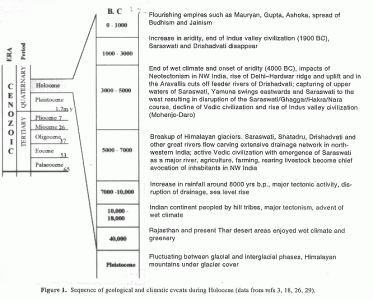
Rivers constitute the lifeline for any country and some of the world’s great civilizations (Indus Valley, Mesopotamian, and Egyptian) have all prospered on banks of river systems. Hindus consider rivers as sacred and have personified them as deities and sung their praises in their religious literature, the Vedas (Rig, Yajur and Atharva), Manusmriti, Puranas and Mahabharata. These cite names of several rivers that existed during the Vedic period and which had their origin in the Himalayas. One such river Saraswati, has been glorified in these texts and referred by various names like Markanda, Hakra, Suprabha, Kanchanakshi, Visala, Manorama etc.1,2, and Mahabharata has exalted Saraswati River as covering the universe and having seven separate names2. Rig veda describes it as one of seven major rivers of Vedic times, the others being, Shatadru (Sutlej), Vipasa (Beas), Askini (Chenab), Parsoni or Airavati (Ravi), Vitasta (Jhelum) and Sindhu (Indus)1,3,4<strong> </strong>(Figure 1). For full 2000 y (between 6000 and 4000 BC), Saraswati had flowed as a great river before it was obliterated in a short span of geological time through a combination of destructive natural events.
1749031501797.gif

Judged in the broader perspective of geological evolution, disappearance or disintegration of rivers, shifting of their courses, capture of one river by another (river piracy), steady decline of waters culminating in drying up of their beds, are all normal responses to tectonism (uplift, faulting, subsidence, tilting), earthquakes, adverse climate and other natural events. Such catastrophic events overtook Saraswati river in quick succession, within a short geological span in the Quaternary period of the Cenozoic era (Figure 1) leading to its decline and disappearance. Similar changes to drainage of rivers have occurred during earlier geological periods also, much before human evolution. A few of the south Indian rivers like the east-flowing Pennar, Palar and Cauvery draining into the Bay of Bengal and west-flowing Swarna, Netravathi and Gurupur draining into the Arabian Sea are known to have changed their courses or got dismembered due to uplift of land. Today, their former courses or palaeochannels can be seen as dry beds5–8.

Saraswati – evolution and drainage

The river Saraswati, during its heydays, is described to be much bigger than Sindhu or the Indus River. During the Vedic period, this river had coursed through the region between modern Yamuna and Sutlej. Though Saraswati is lost, many of its contemporary rivers like Markanda, Chautang and Ghaggar have outlived it and survived till today. All the big rivers of this period –
Saraswati, Shatadru (Sutlej), Yamuna derived their waters from glaciers which had extensively covered the Himalayas during the Pleistocene times. The thawing of these glaciers during Holocene, the warm period that followed, generated many rivers, big and small, coursing down the Himalayan slopes. The melting of glaciers has also been referred in Rigvedic literature, in mythological terms, as an outcome of war between God Indra and the demon Vritra1,9. The enormity of waters available for agriculture and other occupations during those times had prompted the religiously bent ancient inhabitants to describe reverentially seven mighty rivers or ‘Sapta Sindhu’, as divine rivers arising from slowly moving serpent (Ahi), an apparent reference to the movement of glaciers3.

According to geological and glaciological studies11,13, Saraswati was supposed to have originated in Bandapunch masiff (Sarawati-Rupin glacier confluence at Naitwar in western Garhwal). Descending through Adibadri, Bhavanipur and Balchapur in the foothills to the plains, the river took roughly a southwesterly course, passing through the plains of Punjab, Haryana,
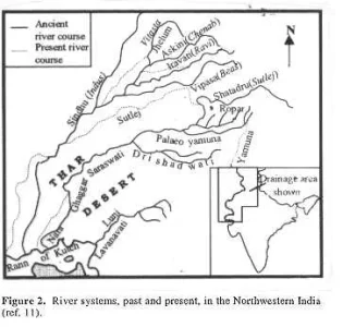
Rajasthan, Gujarat and finally it is believed to have debouched into the ancient Arabian Sea at the Great Rann of Kutch. In this long journey, Saraswati was believed to have had three tributaries, Shatadru (Sutlej) arising from Mount Kailas, Drishadvati from Siwalik Hills and the old Yamuna. Together, they flowed along a channel, presently identified as that of the Ghaggar river, also called Hakra River in Rajasthan and Nara in Sindh1,11 (Figure 2). The rivers, Saraswati and Ghaggar, are therefore supposed to be one and the same, though a few workers use the name Ghaggar to describe Saraswati’s upper course and Hakra to its lower course, while some others refer Saraswati of weak and declining stage, by the name Ghaggar12.
1749031612921.webp


philological debate has taken place about the roots of the nomenclature ‘Saraswati’, which is referred to by the name Harkhaiti or Haravaiti (in Avesta) in regions further west of India. The contentious point debated is whether the syllable Ha in the river’s name changed to Sa, later in India or Sa to Ha outside India. The choice of the name, Saraswati or Harkhaiti, depended upon whether one considered Aryans, the ancient inhabitants along this riverine system, as indigenous people who, upon their migration, carried the name Saraswati westwards where linguistic growth changed Sa soon to Ha; or, whether they were migrants from west of India who brought with them the name Harakhaiti which changed to Saraswati once they settled here2. Apart from the nomenclature, the riverine systems of the period draining northwestern India had generated considerable discussion among the scholars about the positions (hierarchy) of the other feeder rivers, big and small, their sources and causes for their shifts which affected the supply of waters to the main rivers hastening their disintegration, e.g. Saraswati and its major tributary, Drishadvati.

Hindu mythology records several legends and anecdotes that are intertwined with the river’s geologically brief existence. Every aspect of the river’s life, right from its birth to its journey down the Himalayas and over the plains towards the Sindhu Sagara (ancient Arabian Sea), have found mention in one religious text or other, like Rigveda, Yajurveda, Atharvaveda,
Brahmana literature, Manusmriti, Mahabharata
and the Puranas1–3. These descriptive legends have often proved helpful in cataloguing some of the natural events of the period and linking some of them with the river’s perturbations. For example, the graphic description of a war between Gods and demons detailed in one of these texts and use of fire (Agni) in the destruction of a demon hiding in the mountains which trembled under the onslaught may possibly refer to volcanic and seismic episodes of the period2. Today, more than 8000 years since the Vedas came into existence, some of the rivers mentioned therein have become defunct or have shifted from their original path. In the earlier years of study, their erstwhile courses were mainly inferred from archaeological evidences. These included sites of ancient settlements (some 1200 are known) of Harappan, Indus or Saraswati civilizations along river banks, the scripts and seals left behind, and references in Hindu mythology to river-bank Ashrams and Yagnya Kundams preserving evidences about the ritual worship practiced by the ancient inhabitants3,10–13.

Over a 3000 year-long period since the Vedic times (Figure 1), the drainage pattern of many rivers had changed much from that described in the earlier religious literature. The decline of Saraswati appears to have commenced between 5000–3000 BC, probably precipitated by a major tectonic event in the Siwalik Hills of Sirmur region. Geologic studies14 indicate destabilizing tectonic events had occurred around the beginning of Pleistocene, about 1.7 my ago in the entire Siwalik domain, extending from Potwar in Pakistan to Assam in India, resulting in massive landslides and avalanches. These disturbances, which continued intermittently, were all linked to uplift of the Himalayas. Presumably, one of these events must have severed the glacier connection and cut off the supply of glacier melt-waters to this river. As a result, Saraswati became non-perennial and dependent on monsoon rains. All its majesty and splendour of the Vedic period dwindled and with the loss of its tributaries, major and minor, Saraswati’s march to oblivion commenced around 3000 BC. Bereft of waters through separation of its tributaries15, which shifted or got captured by other neighbouring river systems, Saraswati remained here and there as disconnected pools and lakes and ultimately became reduced to a dry channel bed. Lunkaransar, Didwana and Sambhar, the Ranns of Jaisalmer, Pachpadra etc., are a few of these notable lakes, some of them highly saline today, the only proof to their freshwater descent being occurrences of gastropod shells in these lake beds16–19. With the decline and disappearance of Saraswati, the ancient civilizations, that it supported, also faded.

Inferences from geologic, remote sensing and geophysical surveys

Considerable tectonic activity connected with Himalayan orogeny continued during the Holocene and later times although uplifts to heights of 3000–4000 m were at their peak during 0.8–0.9 my span. The high elevation of the mountains perturbed the wind circulation patterns and induced climatic changes. Moderate terrain of earlier times became rugged and hilly affecting the channels of rivers14. That was the scenario of the Himalayan region when Saraswati emerged as a major river about 9000 y ago20 and flowed in all splendour during the vedic times till its decline to an impermanent monsoon dependent state some 4000 y later.

Bulk of earlier studies on Saraswati pertain more to the civilizations that flourished along its banks and many of the reasons attributed for the decline of this river were speculative. The impacts of middle to late Quaternary geologic events on the river systems in this region, however, had received only cursory attention. Awareness to the potentialities of geologic, meteorologic, climatic and other cyclic events, basically triggered by plate tectonism, earth’s orbital and tilt variations and similar global phenomena came up much later. Attempts to investigate their roles over the decline and desiccation of Saraswati began only since close of nineteenth century21–23 and gained momentum during the last three decades. Oldham23, a geologist of Geological Survey of India, was one of the first to offer as early as 1886, geological comments about Saraswati. According to him, the present dry-bed of Ghaggar River represents Saraswati’s former course and that its disappearance was precipitated when its waters were captured by Sutlej and Yamuna. This view differed from that of several others who felt that Saraswati vanished due to lack of rainfall. However, later-day meteorological research about palaeoclimates11,24–27, oxygen isotopic studies36, thermouminescenct (TL) dating28 of wind-borne and river-borne sands in the Thar desert region, radiocarbon dating of lake-bed deposits48 and archaeological evidences29,30 have all indicated that during early to middle Pleistocene period this region had enjoyed wetter climate, heavy rainfall and even recurring floods and that increase in aridity commenced by mid-Holocene (5000–3000 BC) only.

Intense investigations during the last thirty years have yielded fruitful data obtained through ground and satellite based techniques as well as from palaeoseismic, and palaeoclimatic records all of which had enabled a good reconstruction of the drainage evolution in northwestern India. In addition, TL-dating of dry-bed sands and isotopic studies of the groundwater below these channels provided useful links in these reconstruction efforts. The observed river-shifts and other changes could also be correlated with specific geologic, seismic or climatic event that occurred during the mid- to late-Quaternary period. Particularly helpful were the information gathered from LANDSAT imagery about location of former river courses in the plains and beneath the Thar desert upto the Rann of Kutch, about existence of palaeo-river valleys and identifying major structural trends (lineaments) in the region3,16,18,31–34. In spite of a large volume of such data, the chain of natural events during the Quaternary period has given rise to different interpretations about the former river courses.

Mainly, Indus and Saraswati, were the two major river systems of northwestern India during the Vedic period but the network of their tributaries, some of which are known to have deviated from their initial course or become non-existent today, have given scope for grouping these rivers into convenient classifications. Sridhar et al.18 have classified the rivers into four main groups (Figure 2) – (i) Sindhu (Indus) and its tributaries Vitasta (Jhelum) and Askini (Chenab); (ii) Shatadru (Sutlej) and its two major tributaries Vipasa (Beas) and Parasuni or Iravati (Ravi); (iii) Saraswati and its three tributaries Markanda, Ghaggar and Patialewali, in its upper reaches and a major tributary in its middle course; (iv) Drishadvati and Lavanavati. Baldev Sahai19 grouped them into Sutlej, Ghaggar and Yamuna systems while Yash Pal and co-workers32 recognized only two major systems –
the Sutlej and the Ghaggar.
1749031817636.gif
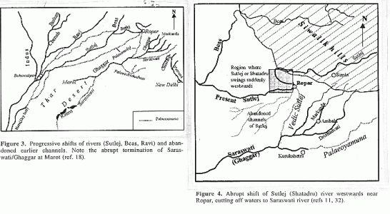
Detailed evaluation of data obtained from remote sensing, geophysical, isotopic and other studies by various workers32,33,35–40<strong> </strong>have been instrumental in sorting out many of the earlier speculative inferences and unsolved aspects of Saraswati river. Yash Pal et al.32 have traced the palaeochannel of this river through Punjab, Haryana and Rajasthan. They found that its course in these States is clearly highlighted in the LANDSAT imagery by the lush cover of vegetation thriving on the rich residual loamy soil along its earlier course. According to their findings, the river disappears abruptly in a depression in Pakistan, instead of in the sea, an observation shared by a few others also. But, digital enhancement studies35 of satellite IRS-1C data launched in 1995, combined with RADAR imagery (from European Remote Sensing satellite ERS-1/2) could identify subsurface features and thus recognize palaeochannels beneath the sands of Thar Desert. These channels are seen to extend upto Fort Abbas and Marot in Pakistan and appear in a line with present dry bed of Ghaggar (Figure 3). This river continues as Nara River in Sindh region and opens into the Rann of Kutch34. Another study33 of satellite derived data has revealed no palaeochannel link between Indus and Saraswati confirming that the two were independent rivers; also, the three palaeochannels, south of Ambala, seen to swerve westwards to join the ancient bed of Ghaggar, are inferred to be tributaries of Saraswati/ Ghaggar, and one among them, probably Drishadvati (Figure 4). The latter disappeared along with Saraswati due to shifts of its feeder streams from Siwalik and Aravalli ranges as well as due to the onset of desertification of Rajasthan15.

Geophysical surveys carried out by the Geological Survey of India to assess groundwater potential in Bikaner, Ganganagar and Jaisalmer districts in western Rajasthan desert areas have brought out several zones of fresh and less saline water in the form of arcuate shaped aquifers similar to several palaeochannels elsewhere in the State. That these subsurface palaeochannels belong to ancient rivers has been confirmed through studies37 on hydrogen, oxygen and carbon isotopes (d2H, d18O, 14C) on shallow and deep groundwater samples from these districts. The isotopic work has also indicated that there is no direct headwater connection or recharge to this groundwater from present day Himalayas. Though the antiquity of these waters and probable links to ancient rivers are thus established, the subsurface palaeochannel route beneath the desert sands obtained from hydrogeological investigations, however, differs from that derived through satellite based studies 16,35,38.

The waning period of Vedic civilization around 3700 BC was also the period that disrupted both Saraswati and Drishadvati18. Several evidences indicate that rivers of this area changed their courses often in the last 5000 y (ref. 32) and one detailed study40 about Saraswati has identified at least four progressive westward shifts in Rajasthan, due to encroaching sands. In their evaluation of the palaeochannel imagery obtained from LANDSAT, Yash Pal et al.32 observed a sudden widening of Ghaggar near Patiala which, they argue, can take place only if a major tributary had joined it. According to them, ancient Shatadru or Sutlej must have been this tributary and possibly ancient Yamuna (palaeo-Yamuna) also flowed into Ghaggar, a conclusion they claim is strengthened by archaeological findings of active life that existed at one time on their banks. During a subsequent period, Shatadru (Sutlej) swung suddenly westwards near Ropar (Figure 4) to join Indus (as also Vipas/Beas and Parasuni/Ravi, its two tributaries), deserting its earlier channel to the sea. This sudden diversion of Sutlej as well as depletion of waters from Drishadvati due to loss of its feeding streams15, appear to be major events that heralded the drying up of Saraswati. Several workers attribute this event to tectonism involving rise of Delhi-Hardwar ridge and uplift in the Aravallis11,15,16,18,32. Capture of Shatadru (Sutlej) by a tributary of Beas through headward erosion or due to diversion of Shatadru (Sutlej) through a fault are also considered as possible reasons32. Structural control over the migration of Saraswati river is also evident from studies41,42 in the Great Indian desert and adjacent parts of western Rajasthan. This area is dissected by several lineaments, some of which (e.g. Luni–Sukri lineament) were reactivated during Pleistocene–Holocene period bringing about alignment of Saraswati with Ghaggar.

Saraswati and the palaeodelta of the Great Rann

Considerable debate has taken place about Saraswati’s entry in the northern part of the Great Rann. Scholars have pointed to references in Rigveda, Manusmriti and Mahabharata about Saraswati disappearing in the sands at Vinäsana and not in the sea; but at the same time, there is also reference in some of these ancient texts about a narrow sea, possibly a creek, coming right upto Bikaner, but which disappeared during the Vedic times10,22. Rigvedic and archaeological references describe how Saraswati supported inland and marine trade and travel and that, around 3000 BC, there was continuous flow of this river upto even the Little Rann13.

The topography at the Great Rann is typically deltaic, developing usually at the mouth of rivers, confirming entry of a few rivers in the sea at this place. Neotectonism, reactivating faults and lineaments which are seen criss-crossing this region, as well as frequent seismicity, apart from Holocene sea-level changes all appear to have influenced development of a peculiar drainage topography in this area. The tilting and sinking of land resulting from the tectonic events have carved characteristic uplands (locally called Bets) representing areas of river mouth deposits, and lowlands which are sites of distributary channels17,28. Satellite imagery, as well as detailed mapping, have revealed network of distributaries and extensive graded deposits, products of Holocene marine regression17. It appears that Indus (Sindhu), Shatadru (Sutlej), Saraswati, Drishadvati (palaeo-Yamuna) and Lavanavati (possibly an ancestor of present day Luni river) had independent courses and opened into the Rann separately. According to Malik
et al.17, at least three rivers – proto-Shatadru (Hakra), Saraswati and Drishadvati must have drained into the Rann around 2000 BC, of which only Sindhu (Indus) has survived. The original delta complex with relict channels, including that of Nara, a continuation of Ghaggar, is today better preserved on the western side but covered by wind-borne deposits on the eastern part of the Great Rann17,43,44.

Yash Pal et al.32 argue that though in the satellite imagery Saraswati/Ghaggar appear to debouch into the sea or a lake near Marot or Beriwala (Pakistan) (Figure 3), this place is far interior, and unlikely to be a palaeo-seacoast, even allowing for rise of sea level during the Holocene marine transgression. In fact studies about coast line changes along the west coast have shown a much lower sea level some 12,000 y back which rose to the present level only later and had remained there for the last 7000 y. These findings, therefore, discount the possibilities of a seacoast at this place45,46 though they do not rule out the river’s entry into the sea that must have existed further south of this site in those times. It may be mentioned that Quaternary neotectonism has submerged vast areas of palaeodelta complex, possibly along with palaeochannels. In this context, it is relevant to take note of the observation that Saraswati’s ancient course in this region is in continuity with another dry river bed–Hakra or Sotra which can be traced through Bikaner to Bhahawalpur and Sind in Pakistan, and finally upto the Rann of Kutch. Such a course appears likely if we backtrack the delta distributaries inland, when it is noticed they connect up with the existing palaeochannels there. Some of these are actually extensions of relict channels seen beneath the sands of Thar Desert, as found out by geophysical and hydrogeological surveys16,17,35,38.

While tectonism had certainly a major role in shaping the fate of Saraswati and other rivers, this could not have been the only agent bringing about various changes that led to its downfall. Even though the role of climate on the disappearance of Saraswati system was underestimated by some of the earlier workers, undoubtedly it must have exercised considerable sway during the Holocene, a period during which major climatic swing has been noted globally26,27,36,47. It is well known that variation in earth’s orbit and tilt of earth’s axis affect the earth’s climate (Milankovitch and albedo forces). A drastic weather change related to these phenomena had peaked around 7000 BC26. Recent studies have shown that the onset of an arid climate occurred in two pulses –
at 4700–3700 and at 2000–1700 BC26, both of which had fairly wide impact not only in India in the desertification of western Rajasthan but in
 
other countries also, like Africa in the development of Saharan and Nubian deserts. The desertification is thought to have occurred 5400 y ago (3400 BC) and its onset greatly affected the monsoon rains and consequently the river systems too. The change from wetter to arid condition destroyed steadily the vegetation, which in turn affected soil moisture, its evaporation, atmospheric circulation and precipitation, all important links in the monsoon evolution chain and, ultimately the climate over the region. However, a recent study48 of water-table fluctuations and radiocarbon estimates from the Lunkansar Lake deposit do not support the views about aridity around 3500 BC, the period when Saraswati and Indus Valley culture were thought to have collapsed. The chronology emerging from these studies show that the once perennial lakes had ceased to be so and they had dried and desiccated more than 1500 y before the dated collapse of the civilization.

Computer based climate simulation studies26, to reproduce the changes to solar heating of the atmosphere due to variations in earth’s tilt and orbit have shown that climate-induced weakening of monsoons over India and north Africa led to desertification in a span of just 300 years. Needless to point out, when one traces the topographic evolution of a place, the influence of a combination of many natural phenomena can be recognized in its build up. It becomes, therefore, very difficult to point out any one reason for some of the major changes to the topography or river systems. The climatic swing that led to sweeping changes in northwestern India was triggered by variations in earth’s orbit and tilt and these departures are known to recur periodically. The latter should, therefore, rise the possibilities for a favourable orientation of these parameters of earth at some future time to initiate climatic conditions for a re-greening of the
Rajasthan desert, rejuvenation of the dry river beds and, hopefully, for a rebirth of Saraswati, like Phoenix out of the ashes.

 
VPN-HSL-468-X60-2x

Latest Replies

Featured Content

Trending Threads

Back
Top