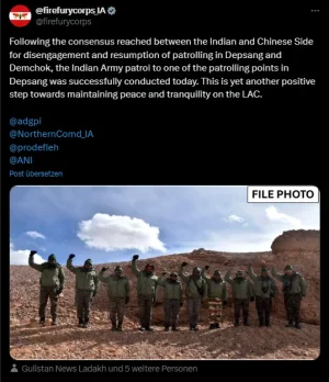
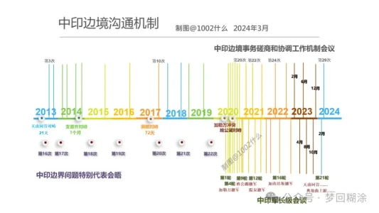
I posted full article here. 1002 checked lots of history maps, and tried to figured out borders, LAC changes within last 60 yrs. Last picture was about the time table negociation rounds between PLA and IA.
Title: Why did China and India engage in a large-scale standoff in the western region
实控线也许会成为将来的国界线,而中印不同的实控线“主张”各自都必须去坚持,这种主张实控线的差异和对实控线主权的坚持,是两国纷争的根源,也是不可退让的底线。

mp.weixin.qq.com
The western section of the China-India border is a historical legacy between the two countries, but the deadly conflict and confrontation along the entire frontier that broke out in 2020 are
unprecedented , and the consequences are also very serious.
The two countries have been in a large-scale standoff on the border for four years, with no resolution in sight, abnormal relations, and widespread "anti-China" sentiment in India.
By the way, the so-called
"softening" of Modi's attitude in his speech is a reverse interpretation by Reuters to promote
closer convergence between the US and India . As long as Modi wants India to become a "great power", it must rely on receiving investment from the US and the West and the transfer of manufacturing from China,
and must rely on the full support of the US defense and military (weapons, technology, QingBao, bases...),
and must stand against China.
Maintaining a controllable "hot peace" on the Sino-Indian border is a desirable long-term strategy.
Significance of the Line of Actual Control
Before 2020, the western section was not silent, but friction and conflict continued.
The root cause was not the policy of whether to move forward or not,
but the different understandings of the two countries on the actual control line .
No matter how many reasons and evidences the two countries cite for their territorial sovereignty disputes, in the end,
the most decisive factor is always the "actual control situation" . Therefore,
the "actual control line" is of great significance . My border guards have repeatedly said in interviews that where my footsteps are, there is the national border; so patrols must be in place.
The same is true for India.
It believes that the actual control line is what it must patrol and maintain. And this line crosses the line claimed by our side,
so there will never be peace .
As long as the border is not demarcated or surveyed, "advancing" and "reaching the border" are the missions of the border guards of the two countries. If the "claimed actual control line" cannot be controlled, then future border negotiations will suffer.
The actual control line of the “claim”
When it comes to the "actual control line", everyone may immediately think that this is an
"actual" and "real" control line . If you cross it, it is an invasion, and if I withdraw, it is "giving up" and "ceding territory." This is also the basis for some people in China to hype "China ceding Pangong Lake" in 2022 .
The fact is that
the "actual control line" is "claimed" and not "real" . The reasons for this are, first, the disputes between the two countries in those years have created many "actual control lines"; second, due to geographical restrictions, neither army can completely garrison and control the entire claimed line, let alone erect barbed wire (which will be destroyed and contrary to the consensus of the two countries), so there are
large cross-activity areas where both armies will patrol . Therefore,
there is no "one" clear actual control line like the India-Pakistan ceasefire line, let alone a "determined national border".
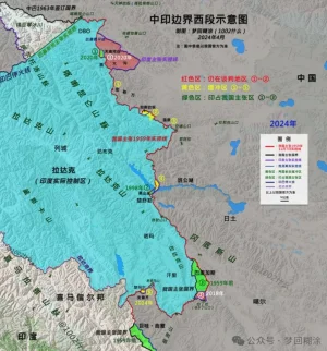
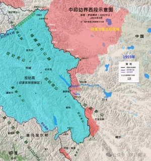
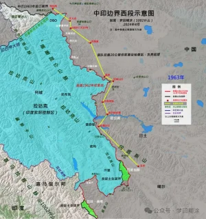
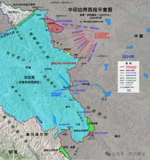
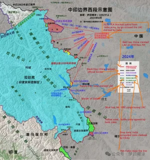
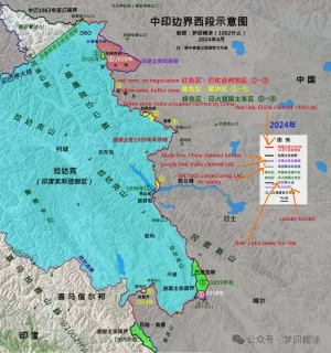
View attachment 14210
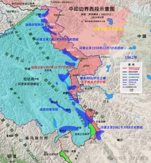
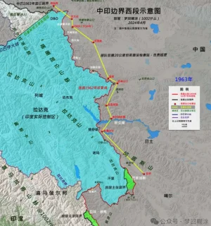
The two countries’ “claimed actual control line”
India claims the sovereignty of the entire Aksai Chin, West Pangong Lake, etc., but our army had already entered this area to set up outposts and build National Highway 219 in the early 1950s.
Therefore, India believes that before November 1959, the actual control line between the two countries was
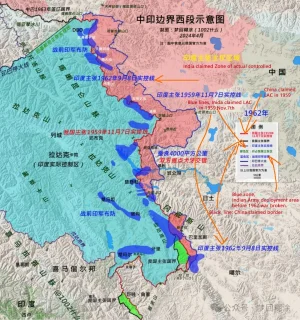
the line connecting the Xinjiang-Tibet Line that China repaired and the Kongka Pass, where the two countries had their first conflict ; there is also a saying that it is the watershed line that inherits the "Ma Jiye-Dou Nale Line", "British Foreign Office Line" and Johnson Line . After the war, India advocated
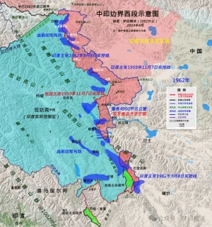
the "September 8, 1962 Line" that was created out of nothing . This was caused by India's "more is more" policy of cannibalization across the border after China officially abolished the ruling power of the Kashag government in 1959 and established an autonomous region government, which led to the shattering of India's dream of a "buffer state in Tibet".
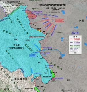
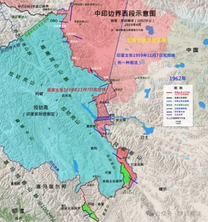
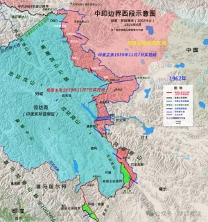
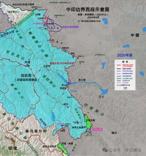
View attachment 14211
View attachment 14212
China has always insisted on
the "Line of Actual Control on November 7, 1959" proposed by the Prime Minister . For decades, it has almost never crossed (except...).
India has never recognized this line. It is a line unilaterally claimed by China. Before 2020, China had never been able to completely block the Indian army from patrolling across the line . There was only endless Indian army crossing the line-confrontation-conflict-repelling the Indian army.
In addition, the only difference between the 1959 Line of Actual Control and the national boundary in the western section is the Indian-occupied area of Barigas.
The People's Daily said that India crossed the line claimed by China and eroded
"4,000 square kilometers" . It can be considered that this is the huge difference between the two lines of China and India, and
it is India's biggest appetite . Of course, the Indian army did not really patrol the entire "4,000 square kilometers" later. As the Indian army has repeatedly clarified, it has a patrol area line in the Tiannan River Valley (enclosing 972 square kilometers), but it does not mean that it has given up the larger claimed actual control area line. So
the real cross-activity area is smaller (see previous articles for details, and I will reorganize it when I have time). '
View attachment 14213
The difficult-to-determine line of control
The two countries reached four border agreements
based on the consensus on maintaining the Line of Actual Control , which formed the cornerstone of "border peace and tranquility". This requires the two countries to clarify what the "Line of Actual Control" is.
However ,
this extremely important work was not carried out due to India's insistence on the "September 8, 1962 Line", which led to huge differences between the two sides. The Line of Actual Control may become the important meaning of the future national boundary, and the difficulty of clarifying it, which affected the overall situation of border reconciliation at that time. So
we called a halt to the work in 2005 .
Instead, it is
India that has repeatedly called for a restart ; of course, just like Modi’s call to “speed up border negotiations between the two countries and resolve disputes as soon as possible”,
there is a prerequisite, that is
, India’s conditions must be respected and China can only make concessions.
This is a dead end, so who is the root cause?
From calm to friction
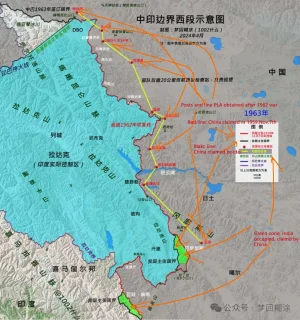
In 1962, our victory was to
"drive the Indian Army out of the 1959 Line of Actual Control (Red Line)" . We have been patrolling the line ever since.
View attachment 14214
For nearly sixty years since then, the border between the two countries has been in a state of "hot peace", except for the second war that almost broke out in 1987. After the Yadong artillery battle in 1967 and the Indian army crossing the border in Toulon in 1975, no deaths have occurred.
But with the development of the times,
variables have emerged. That is infrastructure . We know that all determination is based on the conditions we have, and one of the important conditions is the development of infrastructure.
When infrastructure allows the army to enter the cross-activity zone more conveniently, the original motivation to maintain the claim line and declare sovereignty will become more firm and resolute. As a result, the two armies frequently "collide".
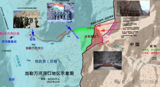
View attachment 14215
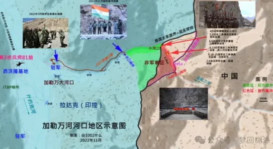
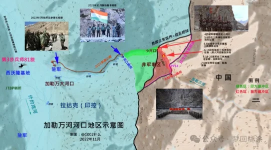
The Galwan conflict is a typical case. Indian analysts have made in-depth analysis that when the Indian army built the DS-DBO strategic highway and the branch roads could easily enter the inner side of the Galwan River estuary, the Indian army entered the intersection area more openly and tried to make it permanent. Therefore, they had to fight back.
View attachment 14216
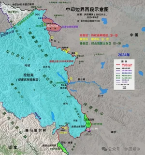
It can be assumed that
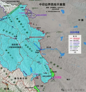
after 2020, the two armies will no longer have overlapping activity areas on the western front, but only overlapping claim areas. The Indian army can no longer cross the Dapingkou of the Tiannan River Valley, the Kalwan River Mouth, the south of Ganandaban, the Changlong River Mouth of Wenquan, the North F4 of Pangong Lake, the Helmet Peak, and the Rechin Pass, etc. The so-called "26 patrol points can no longer be patrolled". The Indian army has set up a total of 65 patrol points in the western section.
View attachment 14217
View attachment 14218
Of course, our army can no longer go to the mouth of the Tiannan River Valley, Heishantou and other territories located on our side of the 1959 actual control line.
View attachment 14219

