Indo-China Border & LAC

Neither did I.

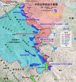
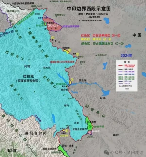
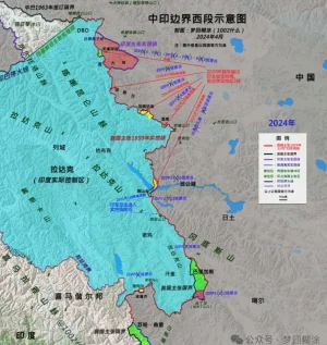
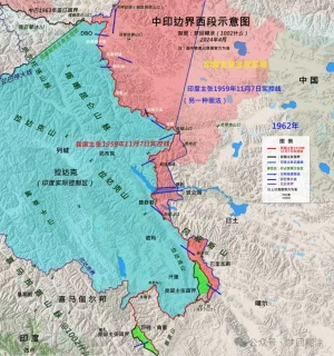
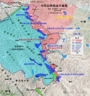
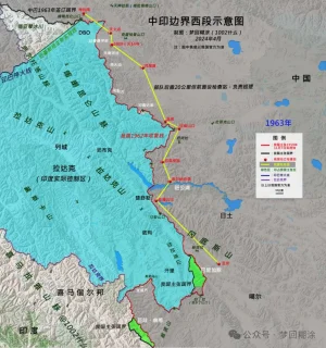
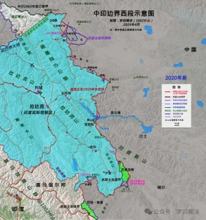
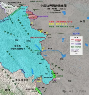
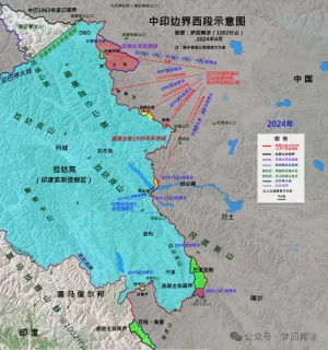
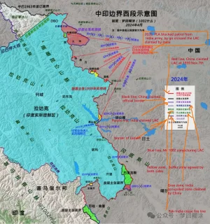
My point was very simple. India had established 65 patrolling points to ensure presence along OUR understanding of LAC (in red, which is quite a bit beyond the LAC you're used to seeing on international maps) access to 26 of which was blocked in 2020... A very simple question. How many of them we've regains access to? No more than 6 by my present understanding. You're welcome to prove me wrong. But until then it means that we've made no solid gains & the "buffer" areas mostly lie on our understanding of LAC even if it's only the Chinese are the ones pulling back, because they were originally on the west side of the red line enforcing the black-dotted LAC line! Which it isn't, because both are moving back. That's worse.

What have we conceded?.. we've let them in areas previously in our sole control to try to do another Galwan after 10 years.

I predicted exactly this even before these recent news were out. SO HOW WAS I WRONG?
View attachment 13757

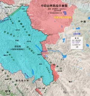
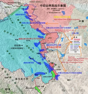
We should be refusing to disengage until they moved back to 1959 pre-war seperation line (in blue) rejecting to recognise any line established by violence against us.

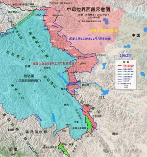
Depsand had only PP-10 to PP-13... That's 4 out of 26, ifffff we're getting access to them.
View attachment 13762
Hot-Spring areas have PP-15 to PP-23. There the engagements were at out PPs. Meaning any disengagement will cause us to lose access to our patrolling points along our LAC.
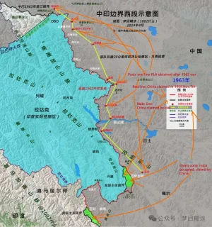
View attachment 13761

How many of them we've regains access to? No more than 6 by my present understanding. You're welcome to prove me wrong

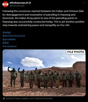
According to the current news and agreement, we have gotten access to all patrol points. Patrolling on all buffer zones has resumed and areas where we were blocked (Depsang & Demchok), we have resumed patrolling as well.

Sweets were exchanged (I hate it) on Karakoram Pass, DBO, Konkang La (PP15), Gogra (PP17), and Chusul, signifying that physical presence & patrolling has started.

This is my current information, you can point out any patrol point where we have no gained access I can shed more light on that.

But until then it means that we've made no solid gains & the "buffer" areas mostly lie on our understanding of LAC even if it's only the Chinese are the ones pulling back, because they were originally on the west side of the red line enforcing the black-dotted LAC line! Which it isn't, because both are moving back. That's worse.

And now that buffer areas are gone, we are back to patrolling our lands, this is invalidated.

What have we conceded?.. we've let them in areas previously in our sole control to try to do another Galwan after 10 years.

I predicted exactly this even before these recent news were out. SO HOW WAS I WRONG?

We have conceded practically nothing apart from some of our hazy understanding of where our control lies. You are still wrong because now we are back to our pre-April 2020 positions.

We should be refusing to disengage until they moved back to 1959 pre-war seperation line (in blue) rejecting to recognise any line established by violence against us.

Respectfully, this is laughable claim. Why would they move back?

They have developed several billion $ of infrastructure worth inside that blue line which they captured from us in 1962 war. Not even giving up entire Arunachal Pradesh will make them fall back to the blue line. We need to be realisitic.

Hot-Spring areas have PP-15 to PP-23. There the engagements were at out PPs. Meaning any disengagement will cause us to lose access to our patrolling points along our LAC.

As pointed out by @Ultraman already, this map by Ajay Shukla is incorrect. Even though, we do have control over the areas starting from PP17 (Gogra) to below. No clashes/ingressions happened in those area.
 
According to the current news and agreement, we have gotten access to all patrol points. Patrolling on all buffer zones has resumed and areas where we were blocked (Depsang & Demchok), we have resumed patrolling as well.

Sweets were exchanged (I hate it) on Karakoram Pass, DBO, Konkang La (PP15), Gogra (PP17), and Chusul, signifying that physical presence & patrolling has started.

This is my current information, you can point out any patrol point where we have no gained access I can shed more light on that.


And now that buffer areas are gone, we are back to patrolling our lands, this is invalidated.


We have conceded practically nothing apart from some of our hazy understanding of where our control lies. You are still wrong because now we are back to our pre-April 2020 positions.


Respectfully, this is laughable claim. Why would they move back?

They have developed several billion $ of infrastructure worth inside that blue line which they captured from us in 1962 war. Not even giving up entire Arunachal Pradesh will make them fall back to the blue line. We need to be realisitic.


As pointed out by @Ultraman already, this map by Ajay Shukla is incorrect. Even though, we do have control over the areas starting from PP17 (Gogra) to below. No clashes/ingressions happened in those area.

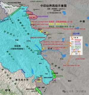
1002 on Weibo post a conclusion article about 2020-2024 border conflict from China's POV, including maps, you would try translation tool.


(might be not accessible, things the article is on wechat, and GOI banned it?)


12.png

56.png

456767.png

56788.png

78900-.png

456787.png
 

Attachments

  • 456787.png
    456787.png
    1.2 MB · Views: 1
1002 on Weibo post a conclusion article about 2020-2024 border conflict from China's POV, including maps, you would try translation tool.


(might be not accessible, things the article is on wechat, and GOI banned it?)

Can you post screenshots ? I cannot open it.
 
Can you post screenshots ? I cannot open it.

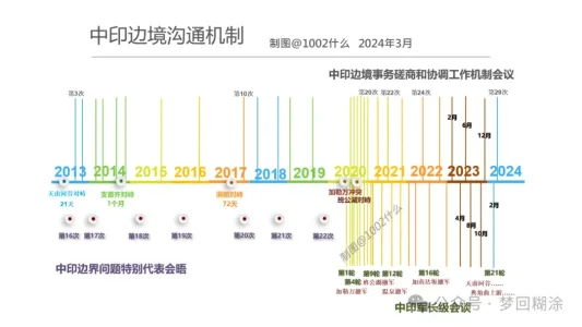
I posted full article here. 1002 checked lots of history maps, and tried to figured out borders, LAC changes within last 60 yrs. Last picture was about the time table negociation rounds between PLA and IA.


Title: Why did China and India engage in a large-scale standoff in the western region

The western section of the China-India border is a historical legacy between the two countries, but the deadly conflict and confrontation along the entire frontier that broke out in 2020 are unprecedented , and the consequences are also very serious. The two countries have been in a large-scale standoff on the border for four years, with no resolution in sight, abnormal relations, and widespread "anti-China" sentiment in India.

By the way, the so-called "softening" of Modi's attitude in his speech is a reverse interpretation by Reuters to promote closer convergence between the US and India . As long as Modi wants India to become a "great power", it must rely on receiving investment from the US and the West and the transfer of manufacturing from China, and must rely on the full support of the US defense and military (weapons, technology, QingBao, bases...), and must stand against China. Maintaining a controllable "hot peace" on the Sino-Indian border is a desirable long-term strategy.


Significance of the Line of Actual Control


Before 2020, the western section was not silent, but friction and conflict continued. The root cause was not the policy of whether to move forward or not, but the different understandings of the two countries on the actual control line .

No matter how many reasons and evidences the two countries cite for their territorial sovereignty disputes, in the end, the most decisive factor is always the "actual control situation" . Therefore, the "actual control line" is of great significance . My border guards have repeatedly said in interviews that where my footsteps are, there is the national border; so patrols must be in place.

The same is true for India. It believes that the actual control line is what it must patrol and maintain. And this line crosses the line claimed by our side, so there will never be peace .

As long as the border is not demarcated or surveyed, "advancing" and "reaching the border" are the missions of the border guards of the two countries. If the "claimed actual control line" cannot be controlled, then future border negotiations will suffer.


The actual control line of the “claim”

When it comes to the "actual control line", everyone may immediately think that this is an "actual" and "real" control line . If you cross it, it is an invasion, and if I withdraw, it is "giving up" and "ceding territory." This is also the basis for some people in China to hype "China ceding Pangong Lake" in 2022 .

The fact is that the "actual control line" is "claimed" and not "real" . The reasons for this are, first, the disputes between the two countries in those years have created many "actual control lines"; second, due to geographical restrictions, neither army can completely garrison and control the entire claimed line, let alone erect barbed wire (which will be destroyed and contrary to the consensus of the two countries), so there are large cross-activity areas where both armies will patrol . Therefore, there is no "one" clear actual control line like the India-Pakistan ceasefire line, let alone a "determined national border".

1959.webp

The two countries’ “claimed actual control line”

India claims the sovereignty of the entire Aksai Chin, West Pangong Lake, etc., but our army had already entered this area to set up outposts and build National Highway 219 in the early 1950s.

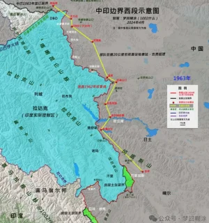
Therefore, India believes that before November 1959, the actual control line between the two countries was the line connecting the Xinjiang-Tibet Line that China repaired and the Kongka Pass, where the two countries had their first conflict ; there is also a saying that it is the watershed line that inherits the "Ma Jiye-Dou Nale Line", "British Foreign Office Line" and Johnson Line . After the war, India advocated the "September 8, 1962 Line" that was created out of nothing . This was caused by India's "more is more" policy of cannibalization across the border after China officially abolished the ruling power of the Kashag government in 1959 and established an autonomous region government, which led to the shattering of India's dream of a "buffer state in Tibet".

640.webp

640 (1).webp


China has always insisted on the "Line of Actual Control on November 7, 1959" proposed by the Prime Minister . For decades, it has almost never crossed (except...). India has never recognized this line. It is a line unilaterally claimed by China. Before 2020, China had never been able to completely block the Indian army from patrolling across the line . There was only endless Indian army crossing the line-confrontation-conflict-repelling the Indian army.

In addition, the only difference between the 1959 Line of Actual Control and the national boundary in the western section is the Indian-occupied area of Barigas.

The People's Daily said that India crossed the line claimed by China and eroded "4,000 square kilometers" . It can be considered that this is the huge difference between the two lines of China and India, and it is India's biggest appetite . Of course, the Indian army did not really patrol the entire "4,000 square kilometers" later. As the Indian army has repeatedly clarified, it has a patrol area line in the Tiannan River Valley (enclosing 972 square kilometers), but it does not mean that it has given up the larger claimed actual control area line. So the real cross-activity area is smaller (see previous articles for details, and I will reorganize it when I have time). '

640 (2).webp

The difficult-to-determine line of control

The two countries reached four border agreements based on the consensus on maintaining the Line of Actual Control , which formed the cornerstone of "border peace and tranquility". This requires the two countries to clarify what the "Line of Actual Control" is.

However , this extremely important work was not carried out due to India's insistence on the "September 8, 1962 Line", which led to huge differences between the two sides. The Line of Actual Control may become the important meaning of the future national boundary, and the difficulty of clarifying it, which affected the overall situation of border reconciliation at that time. So we called a halt to the work in 2005 .

Instead, it is India that has repeatedly called for a restart ; of course, just like Modi’s call to “speed up border negotiations between the two countries and resolve disputes as soon as possible”, there is a prerequisite, that is , India’s conditions must be respected and China can only make concessions.

This is a dead end, so who is the root cause?


From calm to friction

In 1962, our victory was to "drive the Indian Army out of the 1959 Line of Actual Control (Red Line)" . We have been patrolling the line ever since.

640 (3).webp

For nearly sixty years since then, the border between the two countries has been in a state of "hot peace", except for the second war that almost broke out in 1987. After the Yadong artillery battle in 1967 and the Indian army crossing the border in Toulon in 1975, no deaths have occurred.

But with the development of the times, variables have emerged. That is infrastructure . We know that all determination is based on the conditions we have, and one of the important conditions is the development of infrastructure.

When infrastructure allows the army to enter the cross-activity zone more conveniently, the original motivation to maintain the claim line and declare sovereignty will become more firm and resolute. As a result, the two armies frequently "collide".

640 (4).webp

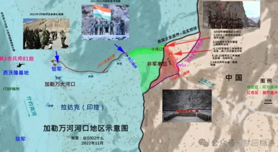
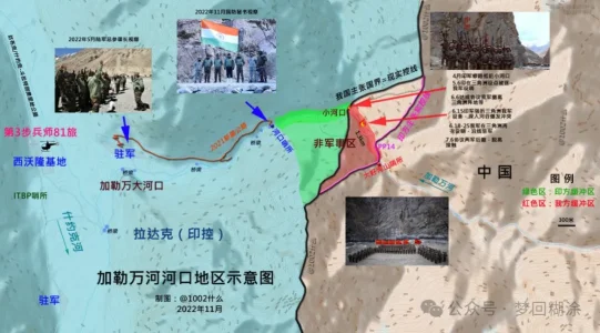
The Galwan conflict is a typical case. Indian analysts have made in-depth analysis that when the Indian army built the DS-DBO strategic highway and the branch roads could easily enter the inner side of the Galwan River estuary, the Indian army entered the intersection area more openly and tried to make it permanent. Therefore, they had to fight back.

640 (5).webp

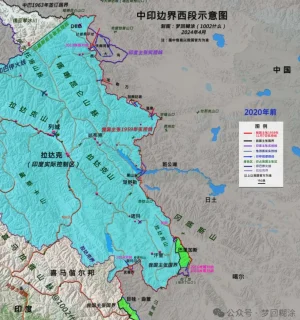
It can be assumed that after 2020, the two armies will no longer have overlapping activity areas on the western front, but only overlapping claim areas. The Indian army can no longer cross the Dapingkou of the Tiannan River Valley, the Kalwan River Mouth, the south of Ganandaban, the Changlong River Mouth of Wenquan, the North F4 of Pangong Lake, the Helmet Peak, and the Rechin Pass, etc. The so-called "26 patrol points can no longer be patrolled". The Indian army has set up a total of 65 patrol points in the western section.

640 (6).webp

640 (7).webp

Of course, our army can no longer go to the mouth of the Tiannan River Valley, Heishantou and other territories located on our side of the 1959 actual control line.

640 (8).webp
 
Last edited by a moderator:
I posted full article here. 1002 checked lots of history maps, and tried to figured out borders, LAC changes within last 60 yrs. Last picture was about the time table negociation rounds between PLA and IA.


Title: Why did China and India engage in a large-scale standoff in the western region

The western section of the China-India border is a historical legacy between the two countries, but the deadly conflict and confrontation along the entire frontier that broke out in 2020 are unprecedented , and the consequences are also very serious. The two countries have been in a large-scale standoff on the border for four years, with no resolution in sight, abnormal relations, and widespread "anti-China" sentiment in India.

By the way, the so-called "softening" of Modi's attitude in his speech is a reverse interpretation by Reuters to promote closer convergence between the US and India . As long as Modi wants India to become a "great power", it must rely on receiving investment from the US and the West and the transfer of manufacturing from China, and must rely on the full support of the US defense and military (weapons, technology, QingBao, bases...), and must stand against China. Maintaining a controllable "hot peace" on the Sino-Indian border is a desirable long-term strategy.


Significance of the Line of Actual Control


Before 2020, the western section was not silent, but friction and conflict continued. The root cause was not the policy of whether to move forward or not, but the different understandings of the two countries on the actual control line .

No matter how many reasons and evidences the two countries cite for their territorial sovereignty disputes, in the end, the most decisive factor is always the "actual control situation" . Therefore, the "actual control line" is of great significance . My border guards have repeatedly said in interviews that where my footsteps are, there is the national border; so patrols must be in place.

The same is true for India. It believes that the actual control line is what it must patrol and maintain. And this line crosses the line claimed by our side, so there will never be peace .

As long as the border is not demarcated or surveyed, "advancing" and "reaching the border" are the missions of the border guards of the two countries. If the "claimed actual control line" cannot be controlled, then future border negotiations will suffer.


The actual control line of the “claim”

When it comes to the "actual control line", everyone may immediately think that this is an "actual" and "real" control line . If you cross it, it is an invasion, and if I withdraw, it is "giving up" and "ceding territory." This is also the basis for some people in China to hype "China ceding Pangong Lake" in 2022 .

The fact is that the "actual control line" is "claimed" and not "real" . The reasons for this are, first, the disputes between the two countries in those years have created many "actual control lines"; second, due to geographical restrictions, neither army can completely garrison and control the entire claimed line, let alone erect barbed wire (which will be destroyed and contrary to the consensus of the two countries), so there are large cross-activity areas where both armies will patrol . Therefore, there is no "one" clear actual control line like the India-Pakistan ceasefire line, let alone a "determined national border".

View attachment 14210

The two countries’ “claimed actual control line”

India claims the sovereignty of the entire Aksai Chin, West Pangong Lake, etc., but our army had already entered this area to set up outposts and build National Highway 219 in the early 1950s.

Therefore, India believes that before November 1959, the actual control line between the two countries was the line connecting the Xinjiang-Tibet Line that China repaired and the Kongka Pass, where the two countries had their first conflict ; there is also a saying that it is the watershed line that inherits the "Ma Jiye-Dou Nale Line", "British Foreign Office Line" and Johnson Line . After the war, India advocated the "September 8, 1962 Line" that was created out of nothing . This was caused by India's "more is more" policy of cannibalization across the border after China officially abolished the ruling power of the Kashag government in 1959 and established an autonomous region government, which led to the shattering of India's dream of a "buffer state in Tibet".

View attachment 14211

View attachment 14212


China has always insisted on the "Line of Actual Control on November 7, 1959" proposed by the Prime Minister . For decades, it has almost never crossed (except...). India has never recognized this line. It is a line unilaterally claimed by China. Before 2020, China had never been able to completely block the Indian army from patrolling across the line . There was only endless Indian army crossing the line-confrontation-conflict-repelling the Indian army.

In addition, the only difference between the 1959 Line of Actual Control and the national boundary in the western section is the Indian-occupied area of Barigas.

The People's Daily said that India crossed the line claimed by China and eroded "4,000 square kilometers" . It can be considered that this is the huge difference between the two lines of China and India, and it is India's biggest appetite . Of course, the Indian army did not really patrol the entire "4,000 square kilometers" later. As the Indian army has repeatedly clarified, it has a patrol area line in the Tiannan River Valley (enclosing 972 square kilometers), but it does not mean that it has given up the larger claimed actual control area line. So the real cross-activity area is smaller (see previous articles for details, and I will reorganize it when I have time). '

View attachment 14213

The difficult-to-determine line of control

The two countries reached four border agreements based on the consensus on maintaining the Line of Actual Control , which formed the cornerstone of "border peace and tranquility". This requires the two countries to clarify what the "Line of Actual Control" is.

However , this extremely important work was not carried out due to India's insistence on the "September 8, 1962 Line", which led to huge differences between the two sides. The Line of Actual Control may become the important meaning of the future national boundary, and the difficulty of clarifying it, which affected the overall situation of border reconciliation at that time. So we called a halt to the work in 2005 .

Instead, it is India that has repeatedly called for a restart ; of course, just like Modi’s call to “speed up border negotiations between the two countries and resolve disputes as soon as possible”, there is a prerequisite, that is , India’s conditions must be respected and China can only make concessions.

This is a dead end, so who is the root cause?


From calm to friction

In 1962, our victory was to "drive the Indian Army out of the 1959 Line of Actual Control (Red Line)" . We have been patrolling the line ever since.

View attachment 14214

For nearly sixty years since then, the border between the two countries has been in a state of "hot peace", except for the second war that almost broke out in 1987. After the Yadong artillery battle in 1967 and the Indian army crossing the border in Toulon in 1975, no deaths have occurred.

But with the development of the times, variables have emerged. That is infrastructure . We know that all determination is based on the conditions we have, and one of the important conditions is the development of infrastructure.

When infrastructure allows the army to enter the cross-activity zone more conveniently, the original motivation to maintain the claim line and declare sovereignty will become more firm and resolute. As a result, the two armies frequently "collide".

View attachment 14215

The Galwan conflict is a typical case. Indian analysts have made in-depth analysis that when the Indian army built the DS-DBO strategic highway and the branch roads could easily enter the inner side of the Galwan River estuary, the Indian army entered the intersection area more openly and tried to make it permanent. Therefore, they had to fight back.

View attachment 14216

It can be assumed that after 2020, the two armies will no longer have overlapping activity areas on the western front, but only overlapping claim areas. The Indian army can no longer cross the Dapingkou of the Tiannan River Valley, the Kalwan River Mouth, the south of Ganandaban, the Changlong River Mouth of Wenquan, the North F4 of Pangong Lake, the Helmet Peak, and the Rechin Pass, etc. The so-called "26 patrol points can no longer be patrolled". The Indian army has set up a total of 65 patrol points in the western section.

View attachment 14217

View attachment 14218

Of course, our army can no longer go to the mouth of the Tiannan River Valley, Heishantou and other territories located on our side of the 1959 actual control line.

View attachment 14219

Lot of minor inaccuracies in the map and narrative😅 But it mainly captures the essence of what is happening and history for 99% of people.

For e.g., it mentions PP10-13 cannot be patrolled, but we know for a fact that according to the agreement we will indeed be patrolling these points (look at the twitter news above).

Also some inaccuracies in claim lines of Galwan, Konkang La (PP15) and Demchok. Where do I start and where do I end !

But that's okay. Ask me anything specific if you want to know. This article is too big to discuss at one go.
 
Closely aligns to "koi nahi ghusa" doctrine

it does accept that increased infra on Indian side played a part maybe to "teach a lesson" to stop routine skirmishes however Chinese were unwilling to escalate beyond a point however we did show willingness to escalate by firing shots, using sff, conducting string of missile test, increased CAP while at the same time increasing trade.
 
I guess we have to accept this "koi nahin ghusa" doctrine as you call it due to the pathetic state of IAF, old age tactics using army, no modern equipment, unimaginative genrols and freebie abuse being rampant across all parties / States as well as gutless bhajipao and naMo + 56in + motabhai being more image concious and bowing to yo media and banias. This Toxic mixture is shafting our defence and border security. Gawd knows if and when we will come out of this.
Closely aligns to "koi nahi ghusa" doctrine

it does accept that increased infra on Indian side played a part maybe to "teach a lesson" to stop routine skirmishes however Chinese were unwilling to escalate beyond a point however we did show willingness to escalate by firing shots, using sff, conducting string of missile test, increased CAP while at the same time increasing trade.
 
Lot of minor inaccuracies in the map and narrative😅 But it mainly captures the essence of what is happening and history for 99% of people.

For e.g., it mentions PP10-13 cannot be patrolled, but we know for a fact that according to the agreement we will indeed be patrolling these points (look at the twitter news above).

Also some inaccuracies in claim lines of Galwan, Konkang La (PP15) and Demchok. Where do I start and where do I end !

But that's okay. Ask me anything specific if you want to know. This article is too big to discuss at one go.

There were two civil/non-government india researchers from our community i respect, one is 1002, he is sino-india map enthusiast as we know. Another guy is Mr Mo, he married a lady from Ladakh, lived in that area and southern India for several yrs, and wrote books about India and i bought it.

This guy walked and researched the LAC on both sides for tens of times, i think had better understanding in person than any member of this forum.


Here i posted a full article about his POV on 2020-2024 conflict, and I agree with him that the most import reason on 2020 was the infra. built-up on both sides, and diffenert understanding on LAC and Zone-AC.

@mist_consecutive plz try to translate.


Title: Did we suffer any losses from this border agreement? Possible future China India relations


近期中印两国终于达成了关于边境争议地区完全脱离接触的协议,对接下去中印关系的走向无疑会有很大的影响。尤其是这个问题在中印边境谈判僵持不下四年之后突然得到解决,老实说让我这个长期关注中印关系走向的“印度女婿”还真感到有些猝不及防。其实吧,前段时间就已经陆陆续续有中印关系缓和的信号释出,因此我在《为什么我最近不写印度了》那篇文章里曾提过一嘴,说印度似乎已经有点熬不下去了;不过当时我还说我们不会在边境问题上让步,没想到居然这么快就找到了解决方案……


对于要不要来谈这件事,我原本有些犹豫,因为很多细节尚不清楚,有些猜想则不是那么方便展开。但想来想去,还是决定把能聊的部分来聊一聊。


一、关于中印边境最终达成的“交叉巡逻”协议

对于中印边境这次最终达成的“交叉巡逻”协议,我就说这么几点吧——


首先,2020年之所以会发生中印边境冲突,真正的起因是2019年印度政府废除宪法370修正案、单方面改变了克什米尔与阿克塞钦等争议领土的政治地位(详见《拉达克往事7·逃离卡吉尔》),从而引发了我方的一系列反制,以及印度的反“反制”,导致冲突升级。当然,官方所说的“印军率先越过实控线”也不能算错,因为中印双方对“实控线”本身就有着不同理解和主张;按照我方对实控线的主张,严格来讲在中印边境东段每时每刻都有印军“越过了实控线”。


其次,我过去在关于中印边境问题的文章里,一直强调一点:我们在西段那些鸟不拉屎的无人区拼命往前推进,主要目的甚至可以说唯一目的就是为我方在谈判中争取更多的筹码,以便在其他地方进行条件交换(参见《西藏西部中印边境考察手札(下)由藏入疆》)。而“筹码”这个东西,说白了本来就是可以打出去的。有未经证实消息称,作为交换,印度在东段的东章瀑布、西巴霞曲等两处争议地区做出了某些让步。


第三,中印以前就达成过类似的“交叉巡逻”边境协议,并通过协议换取了边境的长期安宁。但凡对中印边境冲突的历史稍有了解,就能明白这种协议跟主权划界无关,更是谈不上割地,没必要上纲上线地讨论。


综上,我认为中国在这次的协议里并没有吃亏。打个比方来讲,有人对你出言不逊,然后你进行“反制”,动手掐了对方脖子,要他道歉;可对方死活不肯道歉,于是你这一掐就掐了四年……虽然直到你最终松手都没有得到道歉,但无论如何已经掐人家四年脖子,我相信这四年里印度要比我们痛苦得多。


好了,中印关系缓和的背景我就讲到这里。关于中印边境以及这次协议的相关问题,推荐大家可以去看独立学者【1002】的知乎和公众号。我跟这哥们儿私底下交流好几年了,之前文章用了很多他的地图,我的实地考察跟他的理论钻研刚好互补。由于知识背景相契合,我们对于边境各种问题的意见都很统一,他的观点基本上可以代表我的观点;如果有分歧的地方,以他为准。


二、如何看待印度这次的决策逻辑


接下去我来讲讲,我如何看待印度这次的决策逻辑,以及中印关系接下去可能的前景。


印度对中国态度的软化,大致是从2024年大选之后开始的。今年印度大选的结果与先前的民调预测结果相去甚远,虽然莫迪还是当选了总理,但事实上他已经不再是之前的那个“莫迪总理”了——因为这是2014年印人党执政以来第一次未能拿到三分之二以上的议会席位,必须跟其他政党联合组阁建立政府。联合政府的模式大大削弱了莫迪的权力,这意味着他没有办法再像之前那样任性地说废钞就废钞、说税改就税改、说修宪就修宪;同时也意味着,新的印度政府将不得不放缓改革的步伐,在进行决策的时候会受到更多的牵制,需要平衡各方的利益。


中印关系涉及到的利益面其实相当复杂,然而莫迪在上一个任期内,为了迎合国内的民族主义情绪以及国外的反华势力,不计代价、不顾现实地强行将中印关系与中印边境纠纷相绑定,采取了一些“一刀切”的极端化排华政策。事实证明,其中一些政策很大程度上伤害了印度自身的利益。即便印度政府的外交班底还是原来那波人,即便印人党和国大党在“排华”战略上具备共识,印度也不得不从务实角度重新审视与中国的关系。因此联合政府上台之后,势必要进行对某些极端化的政策进行“纠错”。这次边境协议的达成正是一个很好的契机,用一些媒体的话来说——“中印之间最大的绊脚石已经搬走了”。


中印边境的状态或许能恢复到2020年之前,但我并不认为,中印关系能够借由这次缓和恢复到2019年的状态。


我曾经说过,从底层逻辑上看,中印关系的本质是中美关系。2020年印度之所以敢于大张旗鼓地排华反华,说到底是美国给的底气。美国当时给印度画了很多大饼,说什么疫情暴露了全球产业链过度依赖中国的弱点,美国要重塑全球产业链,新的全球产业链要把中国排除在外,而印度显然是接替中国的“不二之选”;只要印度一心一意跟着美国一起干,就能取中国而代之成为“全球制造中心”……一个想打击中国的制造业,一个想接手中国的制造业,一个愿意出钱,一个愿意出力,于是美印一拍即合(参见《戛然而止的大跃进与图穷匕见的“去中国化”》《后疫情时代的印度真的会成为全球产业链的“救世主”吗?》)。


如今四年时间过去了,我们不能说美国的战略毫无成效,但至少并没有达到预期的成效。除了他们的做法违背自由市场经济规律之外,关键还在于,美国在2020年时恐怕没想到自己会需要应对那么多烂摊子,用“内外交困”来形容也不为过——俄乌战争、“什叶派新月”与以色列的冲突加剧,都在考验美国的外交决策力和国家能力。这些区域冲突虽然远在万里之外,但深刻地影响着美国的国家利益,占用了美国大量注意力,“反华事业”不得不暂时放缓。


与此同时,美国的内政也在持续撕裂,临近大选风波不断,选情反转了好几次,其政局的稳定性面临着严峻的挑战……怎么看美国眼下都是自顾不暇,别说“重塑世界新秩序”了,就连“维持世界旧秩序”都力有不逮。美国的颓势被印度看在眼里,擅长见风使舵的印度,自然要重新掂量一下——是否还值得为了美国画的“大饼”继续反华呢?


我知道很多中国读者瞧不起印度,但我们无法否认,印度在国际政治上的重要性和话语权实打实地在与日俱增。凭借着自己的人口和GDP体量,印度不但有能力、也十分擅长搞外交制衡术。甚至可以说,长期以来“制衡”都是印度外交政策最核心的指导思想,众所周知的 “不结盟运动”,正是印度外交制衡术的具体实践。


外交制衡的原理,是利用大国之间竞争关系,谋求自己的利益最大化。这一策略并非印度首创,在近现代史上早已被多次成功运用,比如一战后的巴列维伊朗利用英苏之间的竞争,在两大帝国的夹缝中为自己谋求到了独立地位。尼赫鲁发起的“不结盟运动”,在美苏冷战的大背景下,将外交制衡的策略发挥到了极致,让印度在外交上“左右逢源”——这就好像一个女生,同时跟两个男人保持暧昧关系,但却又不跟任何一个确立正式关系;通过利用男人之间的竞争,让两个男人都变成自己的“舔狗”。


尼赫鲁的“不结盟运动”,正是通过让印度游走于两个超级大国集团之间,利用它们彼此的竞争为印度争取更多利益。由于美苏两国都希望拉拢印度、都害怕印度倒向对方阵营,印度从中得到了远超其应得的资源。比方说当时美国为印度提供了农业技术支持,帮助印度完成了“绿色革命”,使粮食产量大幅提升;而苏联则提供了大量工业化项目和军事援助,推动了印度的工业化——两个超级大国当年简直就跟舔狗似的,唯恐自己巴结不上印度。


印度这一外交策略提供了一种成功范式,从尼赫鲁时代一直延续至今,这一策略的核心原则有两个——


其一,保持自己外交上的独立性,避免过度依赖某一方势力;不把所有的鸡蛋放在同一个篮子里,从而降低大国竞争造成的风险,同时也避免自己被迫卷入大国之间的冲突。


其二,确保印度的自身利益最大化。一旦与某一阵营深度绑定,可能会需要为该阵营的大局利益做出牺牲和妥协;没有明确的站队,能够让印度的外交政策更加灵活,时刻根据自己的利益需求进行调整。


众所周知,印度一方面加入了美国主导的“印太战略”,是QUAD“四方安全对话”的成员;另一方面又加入了由中俄主导的“金砖国家”“上合组织”——这种“双轨外交”使得印度可以在多个领域获得最大化的利益。例如在技术引进、投资等方面跟美西方阵营合作,同时在贸易、国防等领域保持与中俄的合作;印度可以一边与美日在亚太地区开展联合军演,另一边又跟中俄一起协调反恐……绝不会说选择了跟A合作,就要跟B老死不相往来。


为了A、B通吃,印度不会跟任何一方进行深度绑定。比方说一直有人觉得QUAD是亚洲版的北约,但事实上QUAD距离北约还差得很远,对印度压根儿没什么约束力——印度既没有加入QUAD的共同防卫条约(攻击任何QUAD国家,相当于攻击整个QUAD),也没有允许美国在印度本土驻军驻防。同时印度跟“金砖”、“上合”也是若即若离,加入这些组织归根结底只是印度进行多领域介入、谋求自身利益最大化的手段罢了;而且越是与对方保持距离,越是能够掌握主动权,得到对方更高的价码。


看懂了印度惯用的伎俩,就应当能够明白——这次中印关系的缓和,本质上只是印度外交制衡策略的一次小幅战术性回调。印度发现,为配合美国战略所牺牲的利益,并没能在美国这边得到相应的补偿,自然要进行调整——一方面及时止损回血,另一方面也是对美国的一种敲打,好让美国加强对印度的重视,给印度更多的实质性利益……要不然,哼哼!


其实吧,我早在之前的文章《后疫情时代的印度真的会成为全球产业链的“救世主”吗?》中就作过预判:美印之间的“合作”本来就各怀鬼胎,只是为了反华的“共同利益”暂时走到一起。美国想要的是一个忠心不二的盟友,但印度的所作所为早就让美国恶心坏了——印度为了能源保障和中亚战略运输通道,长期坚定地支持俄罗斯和伊朗,还跑到五眼联盟的地盘上搞暗杀……美国为了不让印度倒向中俄阵营,忍着不跟印度撕破脸,恐怕都已经要憋出内伤了;反过来看,中国容忍印度的胡作非为,又何尝不是同样的原因?这正是印度外交策略上的高明之处,“恃宠而骄”不断试探大国的底线,充分利用大国竞争来拿捏住大国的软肋……只要大国持续在竞争,印度就能持续从中获益。


三、此番中印关系缓和又能走多远?

那么这次中印关系的缓和,又能走多远呢?关于这点,同样可以从印度这种由自身利益主导的决策逻辑来推断。


中印之间有竞争也有合作,但总的来说,竞争要多于可以合作共赢的领域。


首先就是两国对边境和领土的控制。领土争端是最典型的零和博弈,你往前多推进一寸,我这里就要少掉一寸。所以这次边境协议中的“交叉巡逻”,只好采用一种“自我欺骗”的方法,将领土争议暂时搁置——我可以来巡逻,你也可以来巡逻,把时间错开,大家不要迎头撞上,就可以假装这里是属于自己的。


其次是地缘政治的影响力。印度一向以南亚霸主自居,总觉得整个南亚和印度洋都该是自己的势力范围;中国的“一带一路”战略对印度在南亚的影响力构成了直接的挑战,尤其中巴经济走廊对印度简直是在骑脸输出,印度怎么能不耿耿于怀?


最后要讲的经贸领域,情况则比较复杂。在中印关系冻结的几年里,中国居然取代美国成为了印度最大的贸易伙伴,而且贸易规模一年比一年大,说明印度对中国有着较高的贸易依存度——这恰恰是一生要强的印度政府最不愿意看到的。


早在尼赫鲁时期,印度就已经定下了“自给自足”(Swadeshi)的基本国策;而莫迪这几年则十分强调“自力更生的印度”(Atmanirbhar Bharat,参见《甘地的诅咒——谈谈印度退出RCEP背后的“印度梦”》)——在各个产业实现全面的“自给自足”,是“印度梦”的重要组成部分。


在我们看来,全球分工合作显然是一种更有效率的经济模式,但印度却对“自给自足”有着极深的执念。他们似乎不信任全球分工,因为在一百年前的“全球分工”中,印度沦为了被剥削掠夺的殖民地;而在这一轮的“全球分工”中,印度显然又成为了中国商品的“倾销地”。印度最早的“自给自足”运动,正是在反抗殖民统治的过程中发展成形的,“只有自给自足才能救印度”的观念对印度犹如思想钢印。中国向印度大量出口商品,无疑勾起了他们对当年殖民掠夺的恐惧,将中国视为“新殖民主义”。对本国制造业的过度保护、对外国商品的过度限制,将会是印度的远期常态。


另一方面,
印度对于中国取得的经济成就,充满了羡慕嫉妒恨。从印度这些年的一些举措来看,他们显然很想要复制中国模式(参见《将抄作业进行到底——谈谈印度的“中国化”与“去中国化”》)。然而地球虽大、世界却很小,恐怕容不下两个14亿人口的国家同时崛起。中国之所以能够在短短二三十年时间里快速崛起、让14亿人脱贫过上好日子,制造业外贸出口起到了至关重要的作用。中国刚好赶上了全球一体化的红利期,外向型经济带来的资金和技术引进、产业升级、就业岗位,形成了良性循环,最终创造了这一发展奇迹。印度先天不具备中国的社会和政治环境,后天又错过了全球化的窗口期,中国的经验恐怕只可借鉴而无法复制。


更大的问题在于,想要以中国为师,你总得把师父领进门吧?中国固然可以成为印度的领路人,但更多时候却是以竞争者面貌出现的——资本家真金白银出海投资又不是做慈善,谁能不垂涎印度这个14亿人口的大市场?


印度政府只想要中国人给他们带路,却不想让中国人来赚钱,因此在中印关系冻结期间,想方设法阻碍中国公民进入印度,只有印度政府认为“有价值”的中国技术人员才拿得到签证——中印航班以及中国公民的赴印签证,从2020年疫情开始之后就没有正常化过。然而即便明知印度不欢迎中国人,在商业利益的驱使下,还是挡不住许多人前赴后继想要去印度。据我所知通过边境偷渡进入印度被抓的中国人就有好几个,这还不包括没抓到的……


四、中印之间人员往来将正常化?


那么这次中印关系缓和之后,中印之间的人员往来有没有可能正常化呢?就我个人认为:直航可能会重开,但像过去那样对中国公民全面开放签证的可能性很小;至于以前那种可以网上申请的印度旅游电子签证,就别抱太大期望了。


这个世界上,没有哪个群体比印度人更会利用规则的漏洞来钻空子,也没有哪个国家的政府比印度政府更懂得如何防范刁民钻空子——这两者长期以来都在相互伤害的过程中“协同演化”。从目前来看,印度政府既不会动摇“自力更生”的战略,也不会放弃发展本国制造业的战略,因此他们必须继续限制中国人和某些中国商品来印度。


连我都能想象出这样一幅图景:一旦全面开放中国公民的印度签证,其结果必然是大量如饥似渴的中国人拿着旅游签证涌入印度做生意,用各种合规或不合规的方法绕过对中资的限制——比方说在当地寻找代理人、分销商,或者直接借用本地企业,然后通过在第三国设立的中转公司进行资金的转入和转出……这种连我都能预见到的情况,印度政府一定会加以预防。


不让中国人直接踏足印度,固然无法阻止中国继续向印度出口商品,至少能有效地限制中资在印度的扩张,限制中国人对印度商贸的影响力;而假如放任中国人来印度实地考察,那很多事情显然就会变得不可控……“防火防盗防中国”的政策实施多年,如何可能一夜之间反转?你让之前的严防死守情何以堪?更何况经过了这几年对中国的“妖魔化宣传”,印度政府的“中国恐惧症”已然病入膏肓,一想到数万不受控的中国人分散在印度各地“刺探”商业情报、军事情报,恐怕会让他们寝食难安。


我不看好印度开放签证,还有一个很重要的原因在于,中国公民、中国企业能否去印度,并不影响眼下中美博弈的大局。


在分析印度决策心态的同时,应当注意到,这次中印关系缓和的时机相当微妙,刚好是金砖峰会前夜——这么重要的协议,必定是高层拍板的;能够这么快达成协议,必然有高层在推动……因此这次中印关系缓和的成果,恐怕会更多体现在政府和外交层面。中印在军事、外交等层面释放出来的积极信号,对中美博弈乃至整个国际形势有着举足轻重的影响。然而中印之间的贸易规模、中国在印度的投资规模,跟中印双边关系的重要程度完全不相匹配。再加上印度政府的重重阻挠,中印在商贸领域的有限合作,对我们眼下的国际形势几乎不会产生任何影响,反倒可能会增加某些产业机密外泄的风险……因此我不认为我方高层会在人员往来问题上给印度施加压力、浪费手上的筹码。


其实吧,中印之间的人员往来长期以来都是不对等的。比方说西藏亚东和普兰口岸,每年允许一定名额的印度香客过来西藏朝圣,却从来没有我们这边的人能够对等通行去印度那边的锡金。许多读者可能不知道,两国之间口岸通商、人员往来,甚至于互设使领馆,经常是靠民间商会等组织推动的;国家利益和民间商会的利益,很多时候并不一致。所以有些国家之间“政热经冷”,而有些则是“政冷经热”


尽管全面开放签证的可能性很小,但我认为印度政府应该会对工作签证、商务签证进行一定程度的松绑。印度政府之前在这些签证上故意设置障碍,纯粹是损人害己。随着中印关系的缓和,也就没有必要再像之前那样毫无理由地拒签一些中国技术人员了。


五、总结


最后总结如下——


第一,印度的外交决策完全以自身利益为主导。
既然这次的缓和属于战术性回调,那么当国际形势发生新的变化之后,他们必然还会进行进一步调整。


第二,美国眼下虽然显现出颓势,但俄乌战争、中美博弈的形势仍不明朗,印度仍在观望,要随时为下次调整做准备,因此不会在对华政策上有太猛烈的转向。


第三,
这次中印关系的缓和,首先将在政治和外交领域产生影响;想要这种“回暖”传递到商界乃至民间,恐怕还需要一段时间。


第四,在中美博弈未决胜负之前,为了不让印度在反华路上一条道走到黑,我们在国家战略层面还是会很重视跟印度的双边关系、对印度保持友好,以免国际环境恶化。


第五,
就算有一天中国的综合实力超过美国,也不要指望印度会跟中国发展出密切的合作关系,领土争议、印度蔵人、巴基斯坦等因素,都是中印之间建立政治互信不可逾越的障碍。


在今后很长一段时间里,中印之间都会是现在这种谁都看不惯谁、谁都干不掉谁、谁都离不开谁(指彻底反目撕破脸)、捏着鼻子一起过日子的状态。
 
Last edited:
I guess we have to accept this "koi nahin ghusa" doctrine as you call it due to the pathetic state of IAF, old age tactics using army, no modern equipment, unimaginative genrols and freebie abuse being rampant across all parties / States as well as gutless bhajipao and naMo + 56in + motabhai being more image concious and bowing to yo media and banias. This Toxic mixture is shafting our defence and border security. Gawd knows if and when we will come out of this.

More concerning will be the Network centric warfare along LAC/LOC when both sides( Pak and China) will relay real time scenario and data to eachother for more accurate assessment of the situation
 
@mod my last long post was co-operated with @mist_consecutive , i posted a long chinese article, and he helped translation,

You deleted my current one, can we do the same if i re-post again?
 
The offramp through "koi nahi ghusa" doctrine was given hours if not days of the combat casualties at Galwan, however the Chinese pursued the "pressure and release" method as mentioned by so called "sinoligist" and ex pm Kevin rudd maybe the chini were emboldened by their man in the throne "Biden" , cheeni uturn and offer of peace just days before the results shows how much they have penetrated the usa , anyway for us dirty bania yindu asans, recently the chini govt is trying to convince that they are not the enemy.

One Chinese member have taken the trouble recently to explain in long post, which is wholly welcome.Thank you.
 

Latest Replies

Featured Content

Trending Threads

Donate via Bitcoin - bc1qpc3h2l430vlfflc8w02t7qlkvltagt2y4k9dc2

qrcode
Back
Top