Indo-China Border & LAC

Meanwhile we can pull the majority sources to focus on LOC, BMPs are deliberately deployed in recent CT operation to send a signal to pak army. Next inline artillery firewrks if paxistan continue to breed terrorists.
Porkistan should be broken up & artificial famine & complete blockade should be imposed to reduce it's jihadi awam . Gaza 2.0 . Nuke this cancer from the face of the earth 🌎.
 
Neither did I.

My point was very simple. India had established 65 patrolling points to ensure presence along OUR understanding of LAC (in red, which is quite a bit beyond the LAC you're used to seeing on international maps) access to 26 of which was blocked in 2020... A very simple question. How many of them we've regains access to? No more than 6 by my present understanding. You're welcome to prove me wrong. But until then it means that we've made no solid gains & the "buffer" areas mostly lie on our understanding of LAC even if it's only the Chinese are the ones pulling back, because they were originally on the west side of the red line enforcing the black-dotted LAC line! Which it isn't, because both are moving back. That's worse.

What have we conceded?.. we've let them in areas previously in our sole control to try to do another Galwan after 10 years.

I predicted exactly this even before these recent news were out. SO HOW WAS I WRONG?
View attachment 13757

We should be refusing to disengage until they moved back to 1959 pre-war seperation line (in blue) rejecting to recognise any line established by violence against us.
For this, one needs will power... neither does have... Political and Military leadership... as simple..
 
China exports armored vehicle type08?

type80 is a tank model

I haven't seen type80 armored vehicles

One more thing,

The grade of arms technology exported by China must not exceed that used at home.
It's translated from Arabic script(left to right) so 08 might've came out as 80.
 
I wonder how many months before the next salami slice by chinks. I give it 4 months
Every time the scale and intensity will be increased significantly. India should definitely prepare for swarm drone tactics. In future the airforce will be tested to just like how they do with Taiwan.
 
All these are agreements on "agreements" so that we can agree to have more meetings on agreements that can lead to agreement on border , both sides always agreeing to have such agreements at least since 1950s.

So the Canada diplomatic row and the Taiwan issues has prompted both to come to a temporary mutual understanding that pull back now settle later.
 
PCL181, fast produced from 2020, around 600 in 5 yrs.

Deployed in Tibet area.

View attachment 13841

View attachment 13842


View attachment 13843


View attachment 13844

View attachment 13845
PLA operating MGS or Rocket Artillery in Tibet is a huge problem for Tibet is a plateau which means flat terrain which further means no place to hide or run as opposed to the Indian side of the LAC which is mostly ridges & valleys .

Further , each such PLA unit must be guarded by an equivalent anti drone unit as well as it'd be that much more vulnerable as well .
 
Geopolitical Tensions over China’s Mega Dam on the Brahmaputra

Is it a folly or simply over-engineering?

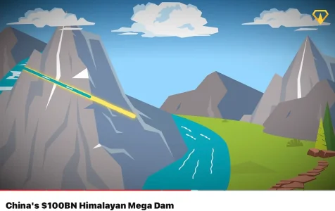
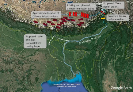
China, known for its strategic maneuvering, is attempting construction of a mega dam, valued between $100 billion on a bend of the Brahmaputra River in Tibet, near the Indian border. The Brahmaputra, a river fed primarily by glacier melt, runs along the northern side of the Himalayas at an elevation of 4,000 to 3,000 meters. Since the Tibetan Plateau sees little rainfall, the river’s flow in this region is mostly a snowmelt. Researchers estimate that only 25 to 33% of the river’s flow in the Assam plains originates in Tibet, while the remaining 65% comes from rainfall in Arunachal Pradesh, Meghalaya, Assam, and surrounding regions. Initially, one might think the dam poses little threat, particularly as it is an inflow dam, with no water is diverted, however, yet concerns rise during the dry season, when the river’s discharge naturally decreases. Moreover, if there is not much flow in the river then Chinese are planning to use water head (difference in elevation) to generate massive amount of electricity. Without enough hydrological data, my guess is that head alone cannot generate that amount of electricity (60 GigaWatts).

China’s ambition to build this dam in such a hazardous location—an earthquake-prone river bend where the river drops 2,500 meters—raises serious questions. The area is highly vulnerable to landslides and other natural disasters. China’s confidence seems rooted in two factors: the availability of labor following the failure of housing projects and failed Belt and Road Initiatives.

The Brahmaputra Dam would be an unprecedented engineering challenge, as the river flows through the world’s deepest known canyon at the bend. China’s plan is to harness the steep 2,500-meter drop to generate power—three times the capacity of the Three Gorges Dam—by constructing three 35-kilometer tunnels beneath the Himalayan slopes. These tunnels would bypass the river’s natural curve, funneling water to turbines on the other side. To feed the turbines, China would build a massive reservoir to store water and release it through the tunnels. However, the region’s geological instability, compounded by the weight of billions of tons of water, could trigger earthquakes, creating a significant risk. Despite these concerns, China appears undeterred.

Why is India Concerned?

China’s construction of the Brahmaputra dam could elevate it to the status of an “upstream superpower,” giving it control over the water supply to downstream nations like India and Bangladesh. Without a formal water-sharing agreement or basin-wide management system, China’s intentions remain suspect. Although earlier reports suggested that China aimed to divert water to its dry regions 3,000 km away, this does not seem to be the case today. Nevertheless, China’s long-term motives are always a suspect.

Another major Indian concern is the potential impact on farming in the Assam plains. The fast-flowing Brahmaputra deposits nutrient-rich soil in these plains, supporting agriculture. A dam would disrupt this natural process. Additionally, the dam could face its own challenges, with sediment building up in the reservoir and potentially blocking the tunnels. That is China’s problem.

Bangladesh, the other downstream country, appears less vocal on the issue. Given its close ties with China, Bangladesh might prefer to look the other way, minimizing any public concerns.

One significant risk is the possibility that China could deliberately release large amounts of water during the rainy season, potentially flooding the Assam plains. To counter this threat, India plans to build an $8 billion dam in Arunachal Pradesh, which would store excess water and release it during the dry season—a promising idea. Additionally, Chinese dam could also complicate India’s plans to link the Brahmaputra with other rivers via the Siliguri Corridor, an idea that has not yet been seriously considered. During any future negotiations over a basin-wide agreement, this project should be addressed and agreed upon. What it means is that when India speaks, China has to listen. Those previous days of Chinese domination are over.}
1730473386396.webp1730473386419.webp
 
Now that Chinese have retreated from two choke points in Ladakh. There is no significance of these points but it was matter of prestige that you are occupying these points with deceit and should vacate, preferably without a fire fight. Patrolling to the peaks thru these points in Despang or grazing Yaks in Demchok is of no strategic significance, but if you want to pick up a fight then that is where you started that is block passage.

The whole world knew that it was stupid and foolish fight but Chinese continued.

Then came the US pressure on China to submit. The Chinese were picking up fights in China sea in the area of U.S. influence (Taiwan, Japan, Philippines etc.). The U.S. wanted China to keep their hands away. Hence sooner than later a fight will ensue. China alone cannot match up to US and combined power of US, Taiwan, Japan and all eastern neighbours hence they began to think which is a greater evil. Is it India or China sea powers backed by US.

It is not hard to conclude that China has nothing to gain in Himalayan peaks. To this they were helped by Russian pressure who is fighting a war in Ukraine, that China relent on its fight with India over nothings and present a unified face at the BRICKS Conference in Russia.

It is likely that Chinese were thinking the same but the Russian pressure helped to give up, hence came the Chinese withdrawal from the two choke points.

It is victory to Modi for his relentless diplomacy to persuade Chinese to leave without a firefight.

Bad news for US as now China can concentrate on anti US front in the China Sea. Also confused Pakistanis will be more bankrupt as they would begin to spend more on war hardware.
 
"The 2020 move in eastern Ladakh, at least in my analysis, seemed an offensive pushback to the change in Jammu and Kashmir’s constitutional status, the declaration of Ladakh as a Union territory and a renewed assertion on retaking Aksai Chin. Xi read it with India’s rushed infra building and increasing force deployments in the area. He decided to pile in the forces to demonstrate to India the gap in capabilities. Or the costs of merely ensuring no Indian territory is lost. This, India has managed to do, albeit at great cost financially."

 
"The 2020 move in eastern Ladakh, at least in my analysis, seemed an offensive pushback to the change in Jammu and Kashmir’s constitutional status, the declaration of Ladakh as a Union territory and a renewed assertion on retaking Aksai Chin. Xi read it with India’s rushed infra building and increasing force deployments in the area. He decided to pile in the forces to demonstrate to India the gap in capabilities. Or the costs of merely ensuring no Indian territory is lost. This, India has managed to do, albeit at great cost financially."

Got to be one of those rare occasions I agree with most of what Clutterji's written.
 
"The 2020 move in eastern Ladakh, at least in my analysis, seemed an offensive pushback to the change in Jammu and Kashmir’s constitutional status, the declaration of Ladakh as a Union territory and a renewed assertion on retaking Aksai Chin. Xi read it with India’s rushed infra building and increasing force deployments in the area. He decided to pile in the forces to demonstrate to India the gap in capabilities. Or the costs of merely ensuring no Indian territory is lost. This, India has managed to do, albeit at great cost financially."

A great discrepancy in your analysis. You did not factor in the mountainous geography and India in control of peaks and passes that large scale invasion is not possible. With India having equal number of forces and hardware which is better winterized that no invasion of any kind is possible. Even salami slicing is next to impossible for the Chinese because India can do the same just as India did on August 29/30, 2020 when in a sudden move India occupied Kailash Heights and put their garrison at Moldo in artillery gun range.

My point is that over confident Chinese realized that no more confrontation. Victory is not possible and no victory for them is defeat for them.

Now began the search for a solution. The coming BRICS meet and Russian pressure on Chinese to stop fights for desolate lands and deny the Americans a geopolitical advantage of China and India fight, finally pushed Chinese to withdraw. BRICS meet was finally selected as the event for this announcement.

India on its own part , wished to concentrate on economics than fight. Even US lost a piece of their geopolitical advantage if India and China withdraw their forces completely.
 
Neither did I.

My point was very simple. India had established 65 patrolling points to ensure presence along OUR understanding of LAC (in red, which is quite a bit beyond the LAC you're used to seeing on international maps) access to 26 of which was blocked in 2020... A very simple question. How many of them we've regains access to? No more than 6 by my present understanding. You're welcome to prove me wrong. But until then it means that we've made no solid gains & the "buffer" areas mostly lie on our understanding of LAC even if it's only the Chinese are the ones pulling back, because they were originally on the west side of the red line enforcing the black-dotted LAC line! Which it isn't, because both are moving back. That's worse.

What have we conceded?.. we've let them in areas previously in our sole control to try to do another Galwan after 10 years.

I predicted exactly this even before these recent news were out. SO HOW WAS I WRONG?
View attachment 13757

We should be refusing to disengage until they moved back to 1959 pre-war seperation line (in blue) rejecting to recognise any line established by violence against us.

Depsand had only PP-10 to PP-13... That's 4 out of 26, ifffff we're getting access to them.
View attachment 13762
Hot-Spring areas have PP-15 to PP-23. There the engagements were at out PPs. Meaning any disengagement will cause us to lose access to our patrolling points along our LAC.
View attachment 13761

-----------------------------------------
@Bleh thanks for the patience.

This will be a 2-part reply. In the first part (this), I will clear out some false assumptions many members have, and establish the ground truth before diving into each of your concerns.

Establishment of Patrol Points and their Significance.

Patrol points are just military checkpoints maintained by Indian Army in Ladakh to mark till our soldiers patrol and establish a loose-sense of what-is-ours. These patrol points are not officially recognized as de-facto Indian boundary even by Army or GoI, let alone any other party/country.

It just means, "Hey, my troops reached at this point and marked it as Indian territory".

And since, LAC is a line threading all these patrol points, this also means, LAC by definition is not a fixed line but fluid to each party's understanding. Eg., if tomorrow I send a expedition patrol to Shaksgam valley ahead of Karakoram pass and put Indian flag there, maybe camp for 2-3 days without anyone opposing it, I can declare it as PP-X and that LAC now passes through this new patrol point.

Lets remember this explanation for future because it is crucial to understand what is "lost" and who "lost".

Does China also have (similar) Patrol Points ?

Yes they do, and they are surprisingly inside Indian territories. For example, Chinese patrols used to reach till Burtse in Depsang, Chinese even made highways till Finger 4, and Chinese patrols reached Chumar post following Pare Chu river. On Arunachal Pradesh side, there situation is even more dire as PLA routinely ingresses deep into valleys and marks them as "Chinese territory".

Point to ponder, China also thinks our patrol points are "way inside" their territory.

Buffer Zones and What they mean / not mean ?

After 2020 clash where both parties ingressed into each-other's perceived territory, the temporary buffer zone was created in 2021 agreement to make sure either party doesn't take any more "aggresive" actions of grabbing more territory or intentionally/unintentionally face off.

It does not mean we vacated that land / gave up control over it (as anti-national forces would like you to believe). Drones and small-patrol teams were used to verify that buffer zone was honored by both sides.

Special Case : What happens when our / their territorial claim is too outrageous ?

PP-10 to 13 are few patrol points in Depsang plateau Indian Army used to patrol (occasionally) with questionable amount of success. Reason is pretty simple, the route is trechearous and no road exist. Its more like a long-range trek completed by ITBP / Army personnel taking few days.

On the other hand, China has excellent road and infrastructure connectivity to these points. They can mobilize thousands of troops and armour within few hours compared to a handful of Indian Army / ITBP men on these points.

Of course, such infrastructure has not been developed in a week by China. It has been ongoing since 1959 after creation of G219 highway in Aksai Chin. India deliberately chose to ignore any infrastructural development, instead doing just "foot" patrols, and in recent times, using ATVs sometime.

So, it must come as no surprise when China is suddenly able to "control" these patrol points and blocking our Army from accessing these areas. Afterall, China has been able to "claim" these areas by building infrastructure while we failed since last 60 years.

Indian Army cannot be expected to claim these areas by force just because Modi / BJP govt. is at the helm. You cannot build 60 years of infrastructure in 6 years.
 

Latest Replies

Featured Content

Trending Threads

Back
Top