Indo-China Border & LAC

Neither did I.

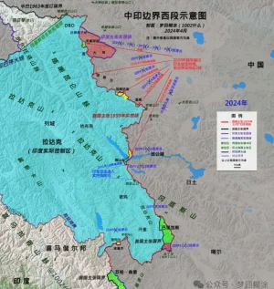
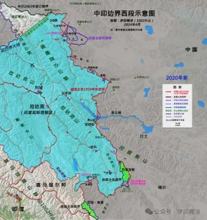
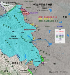
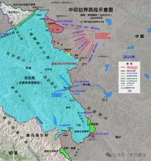
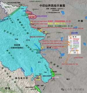
My point was very simple. India had established 65 patrolling points to ensure presence along OUR understanding of LAC (in red, which is quite a bit beyond the LAC you're used to seeing on international maps) access to 26 of which was blocked in 2020... A very simple question. How many of them we've regains access to? No more than 6 by my present understanding. You're welcome to prove me wrong. But until then it means that we've made no solid gains & the "buffer" areas mostly lie on our understanding of LAC even if it's only the Chinese are the ones pulling back, because they were originally on the west side of the red line enforcing the black-dotted LAC line! Which it isn't, because both are moving back. That's worse.

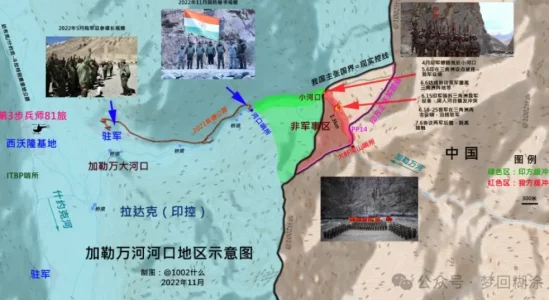
What have we conceded?.. we've let them in areas previously in our sole control to try to do another Galwan after 10 years.

I predicted exactly this even before these recent news were out. SO HOW WAS I WRONG?
View attachment 13757

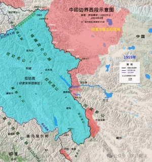
We should be refusing to disengage until they moved back to 1959 pre-war seperation line (in blue) rejecting to recognise any line established by violence against us.

Depsand had only PP-10 to PP-13... That's 4 out of 26, ifffff we're getting access to them.
View attachment 13762
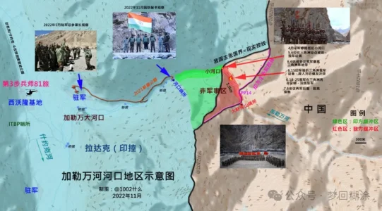
Hot-Spring areas have PP-15 to PP-23. There the engagements were at out PPs. Meaning any disengagement will cause us to lose access to our patrolling points along our LAC.
View attachment 13761

How many of them we've regains access to? No more than 6 by my present understanding. You're welcome to prove me wrong

According to the current news and agreement, we have gotten access to all patrol points. Patrolling on all buffer zones has resumed and areas where we were blocked (Depsang & Demchok), we have resumed patrolling as well.

Sweets were exchanged (I hate it) on Karakoram Pass, DBO, Konkang La (PP15), Gogra (PP17), and Chusul, signifying that physical presence & patrolling has started.

This is my current information, you can point out any patrol point where we have no gained access I can shed more light on that.

But until then it means that we've made no solid gains & the "buffer" areas mostly lie on our understanding of LAC even if it's only the Chinese are the ones pulling back, because they were originally on the west side of the red line enforcing the black-dotted LAC line! Which it isn't, because both are moving back. That's worse.

And now that buffer areas are gone, we are back to patrolling our lands, this is invalidated.

What have we conceded?.. we've let them in areas previously in our sole control to try to do another Galwan after 10 years.

I predicted exactly this even before these recent news were out. SO HOW WAS I WRONG?

We have conceded practically nothing apart from some of our hazy understanding of where our control lies. You are still wrong because now we are back to our pre-April 2020 positions.

We should be refusing to disengage until they moved back to 1959 pre-war seperation line (in blue) rejecting to recognise any line established by violence against us.

Respectfully, this is laughable claim. Why would they move back?

They have developed several billion $ of infrastructure worth inside that blue line which they captured from us in 1962 war. Not even giving up entire Arunachal Pradesh will make them fall back to the blue line. We need to be realisitic.

Hot-Spring areas have PP-15 to PP-23. There the engagements were at out PPs. Meaning any disengagement will cause us to lose access to our patrolling points along our LAC.

As pointed out by @Ultraman already, this map by Ajay Shukla is incorrect. Even though, we do have control over the areas starting from PP17 (Gogra) to below. No clashes/ingressions happened in those area.
 
According to the current news and agreement, we have gotten access to all patrol points. Patrolling on all buffer zones has resumed and areas where we were blocked (Depsang & Demchok), we have resumed patrolling as well.

Sweets were exchanged (I hate it) on Karakoram Pass, DBO, Konkang La (PP15), Gogra (PP17), and Chusul, signifying that physical presence & patrolling has started.

This is my current information, you can point out any patrol point where we have no gained access I can shed more light on that.


And now that buffer areas are gone, we are back to patrolling our lands, this is invalidated.


We have conceded practically nothing apart from some of our hazy understanding of where our control lies. You are still wrong because now we are back to our pre-April 2020 positions.


Respectfully, this is laughable claim. Why would they move back?

They have developed several billion $ of infrastructure worth inside that blue line which they captured from us in 1962 war. Not even giving up entire Arunachal Pradesh will make them fall back to the blue line. We need to be realisitic.


As pointed out by @Ultraman already, this map by Ajay Shukla is incorrect. Even though, we do have control over the areas starting from PP17 (Gogra) to below. No clashes/ingressions happened in those area.

1002 on Weibo post a conclusion article about 2020-2024 border conflict from China's POV, including maps, you would try translation tool.


(might be not accessible, things the article is on wechat, and GOI banned it?)


12.png

56.png

456767.png

56788.png

78900-.png

456787.png
 

Attachments

  • 456787.png
    456787.png
    1.2 MB · Views: 4
1002 on Weibo post a conclusion article about 2020-2024 border conflict from China's POV, including maps, you would try translation tool.


(might be not accessible, things the article is on wechat, and GOI banned it?)

Can you post screenshots ? I cannot open it.
 
Can you post screenshots ? I cannot open it.

I posted full article here. 1002 checked lots of history maps, and tried to figured out borders, LAC changes within last 60 yrs. Last picture was about the time table negociation rounds between PLA and IA.


Title: Why did China and India engage in a large-scale standoff in the western region

The western section of the China-India border is a historical legacy between the two countries, but the deadly conflict and confrontation along the entire frontier that broke out in 2020 are unprecedented , and the consequences are also very serious. The two countries have been in a large-scale standoff on the border for four years, with no resolution in sight, abnormal relations, and widespread "anti-China" sentiment in India.

By the way, the so-called "softening" of Modi's attitude in his speech is a reverse interpretation by Reuters to promote closer convergence between the US and India . As long as Modi wants India to become a "great power", it must rely on receiving investment from the US and the West and the transfer of manufacturing from China, and must rely on the full support of the US defense and military (weapons, technology, QingBao, bases...), and must stand against China. Maintaining a controllable "hot peace" on the Sino-Indian border is a desirable long-term strategy.


Significance of the Line of Actual Control


Before 2020, the western section was not silent, but friction and conflict continued. The root cause was not the policy of whether to move forward or not, but the different understandings of the two countries on the actual control line .

No matter how many reasons and evidences the two countries cite for their territorial sovereignty disputes, in the end, the most decisive factor is always the "actual control situation" . Therefore, the "actual control line" is of great significance . My border guards have repeatedly said in interviews that where my footsteps are, there is the national border; so patrols must be in place.

The same is true for India. It believes that the actual control line is what it must patrol and maintain. And this line crosses the line claimed by our side, so there will never be peace .

As long as the border is not demarcated or surveyed, "advancing" and "reaching the border" are the missions of the border guards of the two countries. If the "claimed actual control line" cannot be controlled, then future border negotiations will suffer.


The actual control line of the “claim”

When it comes to the "actual control line", everyone may immediately think that this is an "actual" and "real" control line . If you cross it, it is an invasion, and if I withdraw, it is "giving up" and "ceding territory." This is also the basis for some people in China to hype "China ceding Pangong Lake" in 2022 .

The fact is that the "actual control line" is "claimed" and not "real" . The reasons for this are, first, the disputes between the two countries in those years have created many "actual control lines"; second, due to geographical restrictions, neither army can completely garrison and control the entire claimed line, let alone erect barbed wire (which will be destroyed and contrary to the consensus of the two countries), so there are large cross-activity areas where both armies will patrol . Therefore, there is no "one" clear actual control line like the India-Pakistan ceasefire line, let alone a "determined national border".

1959.webp

The two countries’ “claimed actual control line”

India claims the sovereignty of the entire Aksai Chin, West Pangong Lake, etc., but our army had already entered this area to set up outposts and build National Highway 219 in the early 1950s.

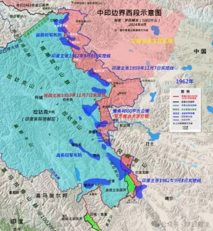
Therefore, India believes that before November 1959, the actual control line between the two countries was the line connecting the Xinjiang-Tibet Line that China repaired and the Kongka Pass, where the two countries had their first conflict ; there is also a saying that it is the watershed line that inherits the "Ma Jiye-Dou Nale Line", "British Foreign Office Line" and Johnson Line . After the war, India advocated the "September 8, 1962 Line" that was created out of nothing . This was caused by India's "more is more" policy of cannibalization across the border after China officially abolished the ruling power of the Kashag government in 1959 and established an autonomous region government, which led to the shattering of India's dream of a "buffer state in Tibet".

640.webp

640 (1).webp


China has always insisted on the "Line of Actual Control on November 7, 1959" proposed by the Prime Minister . For decades, it has almost never crossed (except...). India has never recognized this line. It is a line unilaterally claimed by China. Before 2020, China had never been able to completely block the Indian army from patrolling across the line . There was only endless Indian army crossing the line-confrontation-conflict-repelling the Indian army.

In addition, the only difference between the 1959 Line of Actual Control and the national boundary in the western section is the Indian-occupied area of Barigas.

The People's Daily said that India crossed the line claimed by China and eroded "4,000 square kilometers" . It can be considered that this is the huge difference between the two lines of China and India, and it is India's biggest appetite . Of course, the Indian army did not really patrol the entire "4,000 square kilometers" later. As the Indian army has repeatedly clarified, it has a patrol area line in the Tiannan River Valley (enclosing 972 square kilometers), but it does not mean that it has given up the larger claimed actual control area line. So the real cross-activity area is smaller (see previous articles for details, and I will reorganize it when I have time). '

640 (2).webp

The difficult-to-determine line of control

The two countries reached four border agreements based on the consensus on maintaining the Line of Actual Control , which formed the cornerstone of "border peace and tranquility". This requires the two countries to clarify what the "Line of Actual Control" is.

However , this extremely important work was not carried out due to India's insistence on the "September 8, 1962 Line", which led to huge differences between the two sides. The Line of Actual Control may become the important meaning of the future national boundary, and the difficulty of clarifying it, which affected the overall situation of border reconciliation at that time. So we called a halt to the work in 2005 .

Instead, it is India that has repeatedly called for a restart ; of course, just like Modi’s call to “speed up border negotiations between the two countries and resolve disputes as soon as possible”, there is a prerequisite, that is , India’s conditions must be respected and China can only make concessions.

This is a dead end, so who is the root cause?


From calm to friction

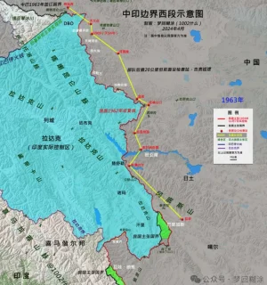
In 1962, our victory was to "drive the Indian Army out of the 1959 Line of Actual Control (Red Line)" . We have been patrolling the line ever since.

640 (3).webp

For nearly sixty years since then, the border between the two countries has been in a state of "hot peace", except for the second war that almost broke out in 1987. After the Yadong artillery battle in 1967 and the Indian army crossing the border in Toulon in 1975, no deaths have occurred.

But with the development of the times, variables have emerged. That is infrastructure . We know that all determination is based on the conditions we have, and one of the important conditions is the development of infrastructure.

When infrastructure allows the army to enter the cross-activity zone more conveniently, the original motivation to maintain the claim line and declare sovereignty will become more firm and resolute. As a result, the two armies frequently "collide".

640 (4).webp

The Galwan conflict is a typical case. Indian analysts have made in-depth analysis that when the Indian army built the DS-DBO strategic highway and the branch roads could easily enter the inner side of the Galwan River estuary, the Indian army entered the intersection area more openly and tried to make it permanent. Therefore, they had to fight back.

640 (5).webp

It can be assumed that after 2020, the two armies will no longer have overlapping activity areas on the western front, but only overlapping claim areas. The Indian army can no longer cross the Dapingkou of the Tiannan River Valley, the Kalwan River Mouth, the south of Ganandaban, the Changlong River Mouth of Wenquan, the North F4 of Pangong Lake, the Helmet Peak, and the Rechin Pass, etc. The so-called "26 patrol points can no longer be patrolled". The Indian army has set up a total of 65 patrol points in the western section.

640 (6).webp

640 (7).webp

Of course, our army can no longer go to the mouth of the Tiannan River Valley, Heishantou and other territories located on our side of the 1959 actual control line.

640 (8).webp
 
Last edited by a moderator:
I posted full article here. 1002 checked lots of history maps, and tried to figured out borders, LAC changes within last 60 yrs. Last picture was about the time table negociation rounds between PLA and IA.


Title: Why did China and India engage in a large-scale standoff in the western region

The western section of the China-India border is a historical legacy between the two countries, but the deadly conflict and confrontation along the entire frontier that broke out in 2020 are unprecedented , and the consequences are also very serious. The two countries have been in a large-scale standoff on the border for four years, with no resolution in sight, abnormal relations, and widespread "anti-China" sentiment in India.

By the way, the so-called "softening" of Modi's attitude in his speech is a reverse interpretation by Reuters to promote closer convergence between the US and India . As long as Modi wants India to become a "great power", it must rely on receiving investment from the US and the West and the transfer of manufacturing from China, and must rely on the full support of the US defense and military (weapons, technology, QingBao, bases...), and must stand against China. Maintaining a controllable "hot peace" on the Sino-Indian border is a desirable long-term strategy.


Significance of the Line of Actual Control


Before 2020, the western section was not silent, but friction and conflict continued. The root cause was not the policy of whether to move forward or not, but the different understandings of the two countries on the actual control line .

No matter how many reasons and evidences the two countries cite for their territorial sovereignty disputes, in the end, the most decisive factor is always the "actual control situation" . Therefore, the "actual control line" is of great significance . My border guards have repeatedly said in interviews that where my footsteps are, there is the national border; so patrols must be in place.

The same is true for India. It believes that the actual control line is what it must patrol and maintain. And this line crosses the line claimed by our side, so there will never be peace .

As long as the border is not demarcated or surveyed, "advancing" and "reaching the border" are the missions of the border guards of the two countries. If the "claimed actual control line" cannot be controlled, then future border negotiations will suffer.


The actual control line of the “claim”

When it comes to the "actual control line", everyone may immediately think that this is an "actual" and "real" control line . If you cross it, it is an invasion, and if I withdraw, it is "giving up" and "ceding territory." This is also the basis for some people in China to hype "China ceding Pangong Lake" in 2022 .

The fact is that the "actual control line" is "claimed" and not "real" . The reasons for this are, first, the disputes between the two countries in those years have created many "actual control lines"; second, due to geographical restrictions, neither army can completely garrison and control the entire claimed line, let alone erect barbed wire (which will be destroyed and contrary to the consensus of the two countries), so there are large cross-activity areas where both armies will patrol . Therefore, there is no "one" clear actual control line like the India-Pakistan ceasefire line, let alone a "determined national border".

View attachment 14210

The two countries’ “claimed actual control line”

India claims the sovereignty of the entire Aksai Chin, West Pangong Lake, etc., but our army had already entered this area to set up outposts and build National Highway 219 in the early 1950s.

Therefore, India believes that before November 1959, the actual control line between the two countries was the line connecting the Xinjiang-Tibet Line that China repaired and the Kongka Pass, where the two countries had their first conflict ; there is also a saying that it is the watershed line that inherits the "Ma Jiye-Dou Nale Line", "British Foreign Office Line" and Johnson Line . After the war, India advocated the "September 8, 1962 Line" that was created out of nothing . This was caused by India's "more is more" policy of cannibalization across the border after China officially abolished the ruling power of the Kashag government in 1959 and established an autonomous region government, which led to the shattering of India's dream of a "buffer state in Tibet".

View attachment 14211

View attachment 14212


China has always insisted on the "Line of Actual Control on November 7, 1959" proposed by the Prime Minister . For decades, it has almost never crossed (except...). India has never recognized this line. It is a line unilaterally claimed by China. Before 2020, China had never been able to completely block the Indian army from patrolling across the line . There was only endless Indian army crossing the line-confrontation-conflict-repelling the Indian army.

In addition, the only difference between the 1959 Line of Actual Control and the national boundary in the western section is the Indian-occupied area of Barigas.

The People's Daily said that India crossed the line claimed by China and eroded "4,000 square kilometers" . It can be considered that this is the huge difference between the two lines of China and India, and it is India's biggest appetite . Of course, the Indian army did not really patrol the entire "4,000 square kilometers" later. As the Indian army has repeatedly clarified, it has a patrol area line in the Tiannan River Valley (enclosing 972 square kilometers), but it does not mean that it has given up the larger claimed actual control area line. So the real cross-activity area is smaller (see previous articles for details, and I will reorganize it when I have time). '

View attachment 14213

The difficult-to-determine line of control

The two countries reached four border agreements based on the consensus on maintaining the Line of Actual Control , which formed the cornerstone of "border peace and tranquility". This requires the two countries to clarify what the "Line of Actual Control" is.

However , this extremely important work was not carried out due to India's insistence on the "September 8, 1962 Line", which led to huge differences between the two sides. The Line of Actual Control may become the important meaning of the future national boundary, and the difficulty of clarifying it, which affected the overall situation of border reconciliation at that time. So we called a halt to the work in 2005 .

Instead, it is India that has repeatedly called for a restart ; of course, just like Modi’s call to “speed up border negotiations between the two countries and resolve disputes as soon as possible”, there is a prerequisite, that is , India’s conditions must be respected and China can only make concessions.

This is a dead end, so who is the root cause?


From calm to friction

In 1962, our victory was to "drive the Indian Army out of the 1959 Line of Actual Control (Red Line)" . We have been patrolling the line ever since.

View attachment 14214

For nearly sixty years since then, the border between the two countries has been in a state of "hot peace", except for the second war that almost broke out in 1987. After the Yadong artillery battle in 1967 and the Indian army crossing the border in Toulon in 1975, no deaths have occurred.

But with the development of the times, variables have emerged. That is infrastructure . We know that all determination is based on the conditions we have, and one of the important conditions is the development of infrastructure.

When infrastructure allows the army to enter the cross-activity zone more conveniently, the original motivation to maintain the claim line and declare sovereignty will become more firm and resolute. As a result, the two armies frequently "collide".

View attachment 14215

The Galwan conflict is a typical case. Indian analysts have made in-depth analysis that when the Indian army built the DS-DBO strategic highway and the branch roads could easily enter the inner side of the Galwan River estuary, the Indian army entered the intersection area more openly and tried to make it permanent. Therefore, they had to fight back.

View attachment 14216

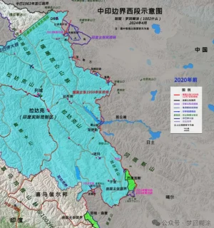
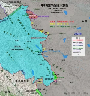
It can be assumed that after 2020, the two armies will no longer have overlapping activity areas on the western front, but only overlapping claim areas. The Indian army can no longer cross the Dapingkou of the Tiannan River Valley, the Kalwan River Mouth, the south of Ganandaban, the Changlong River Mouth of Wenquan, the North F4 of Pangong Lake, the Helmet Peak, and the Rechin Pass, etc. The so-called "26 patrol points can no longer be patrolled". The Indian army has set up a total of 65 patrol points in the western section.

View attachment 14217

View attachment 14218

Of course, our army can no longer go to the mouth of the Tiannan River Valley, Heishantou and other territories located on our side of the 1959 actual control line.

View attachment 14219

Lot of minor inaccuracies in the map and narrative😅 But it mainly captures the essence of what is happening and history for 99% of people.

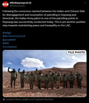
For e.g., it mentions PP10-13 cannot be patrolled, but we know for a fact that according to the agreement we will indeed be patrolling these points (look at the twitter news above).

Also some inaccuracies in claim lines of Galwan, Konkang La (PP15) and Demchok. Where do I start and where do I end !

But that's okay. Ask me anything specific if you want to know. This article is too big to discuss at one go.
 
Closely aligns to "koi nahi ghusa" doctrine

it does accept that increased infra on Indian side played a part maybe to "teach a lesson" to stop routine skirmishes however Chinese were unwilling to escalate beyond a point however we did show willingness to escalate by firing shots, using sff, conducting string of missile test, increased CAP while at the same time increasing trade.
 
I guess we have to accept this "koi nahin ghusa" doctrine as you call it due to the pathetic state of IAF, old age tactics using army, no modern equipment, unimaginative genrols and freebie abuse being rampant across all parties / States as well as gutless bhajipao and naMo + 56in + motabhai being more image concious and bowing to yo media and banias. This Toxic mixture is shafting our defence and border security. Gawd knows if and when we will come out of this.

More concerning will be the Network centric warfare along LAC/LOC when both sides( Pak and China) will relay real time scenario and data to eachother for more accurate assessment of the situation
 
@mod my last long post was co-operated with @mist_consecutive , i posted a long chinese article, and he helped translation,

You deleted my current one, can we do the same if i re-post again?
 
The offramp through "koi nahi ghusa" doctrine was given hours if not days of the combat casualties at Galwan, however the Chinese pursued the "pressure and release" method as mentioned by so called "sinoligist" and ex pm Kevin rudd maybe the chini were emboldened by their man in the throne "Biden" , cheeni uturn and offer of peace just days before the results shows how much they have penetrated the usa , anyway for us dirty bania yindu asans, recently the chini govt is trying to convince that they are not the enemy.

One Chinese member have taken the trouble recently to explain in long post, which is wholly welcome.Thank you.
 
@mod my last long post was co-operated with @mist_consecutive , i posted a long chinese article, and he helped translation,

You deleted my current one, can we do the same if i re-post again?

The article you posted is almost a book-sized. Too big for anyone to read and be a meaningful discussion.

If you want to post, follow these -

  • Keep your messages short. Preferably no more than 2-3 paragraphs. Break it into multiple posts if bigger.
  • Translate it in english before posting. This is not our responsibility to translate, but yours.
 
According to the current news and agreement, we have gotten access to all patrol points. Patrolling on all buffer zones has resumed and areas where we were blocked (Depsang & Demchok), we have resumed patrolling as well.

Sweets were exchanged (I hate it) on Karakoram Pass, DBO, Konkang La (PP15), Gogra (PP17), and Chusul, signifying that physical presence & patrolling has started.

This is my current information, you can point out any patrol point where we have no gained access I can shed more light on that.


And now that buffer areas are gone, we are back to patrolling our lands, this is invalidated.


We have conceded practically nothing apart from some of our hazy understanding of where our control lies. You are still wrong because now we are back to our pre-April 2020 positions.


Respectfully, this is laughable claim. Why would they move back?

They have developed several billion $ of infrastructure worth inside that blue line which they captured from us in 1962 war. Not even giving up entire Arunachal Pradesh will make them fall back to the blue line. We need to be realisitic.


As pointed out by @Ultraman already, this map by Ajay Shukla is incorrect. Even though, we do have control over the areas starting from PP17 (Gogra) to below. No clashes/ingressions happened in those area.


This article suggest the situation is much better for us... All the PPs of Depsang plains are back open, that's nearly 20km (200km²) area where a single shot fired.

Charding La is also open.

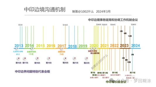
I posted full article here. 1002 checked lots of history maps, and tried to figured out borders, LAC changes within last 60 yrs. Last picture was about the time table negociation rounds between PLA and IA.


Title: Why did China and India engage in a large-scale standoff in the western region

The western section of the China-India border is a historical legacy between the two countries, but the deadly conflict and confrontation along the entire frontier that broke out in 2020 are unprecedented , and the consequences are also very serious. The two countries have been in a large-scale standoff on the border for four years, with no resolution in sight, abnormal relations, and widespread "anti-China" sentiment in India.

By the way, the so-called "softening" of Modi's attitude in his speech is a reverse interpretation by Reuters to promote closer convergence between the US and India . As long as Modi wants India to become a "great power", it must rely on receiving investment from the US and the West and the transfer of manufacturing from China, and must rely on the full support of the US defense and military (weapons, technology, QingBao, bases...), and must stand against China. Maintaining a controllable "hot peace" on the Sino-Indian border is a desirable long-term strategy.


Significance of the Line of Actual Control


Before 2020, the western section was not silent, but friction and conflict continued. The root cause was not the policy of whether to move forward or not, but the different understandings of the two countries on the actual control line .

No matter how many reasons and evidences the two countries cite for their territorial sovereignty disputes, in the end, the most decisive factor is always the "actual control situation" . Therefore, the "actual control line" is of great significance . My border guards have repeatedly said in interviews that where my footsteps are, there is the national border; so patrols must be in place.

The same is true for India. It believes that the actual control line is what it must patrol and maintain. And this line crosses the line claimed by our side, so there will never be peace .

As long as the border is not demarcated or surveyed, "advancing" and "reaching the border" are the missions of the border guards of the two countries. If the "claimed actual control line" cannot be controlled, then future border negotiations will suffer.


The actual control line of the “claim”

When it comes to the "actual control line", everyone may immediately think that this is an "actual" and "real" control line . If you cross it, it is an invasion, and if I withdraw, it is "giving up" and "ceding territory." This is also the basis for some people in China to hype "China ceding Pangong Lake" in 2022 .

The fact is that the "actual control line" is "claimed" and not "real" . The reasons for this are, first, the disputes between the two countries in those years have created many "actual control lines"; second, due to geographical restrictions, neither army can completely garrison and control the entire claimed line, let alone erect barbed wire (which will be destroyed and contrary to the consensus of the two countries), so there are large cross-activity areas where both armies will patrol . Therefore, there is no "one" clear actual control line like the India-Pakistan ceasefire line, let alone a "determined national border".

View attachment 14210

The two countries’ “claimed actual control line”

India claims the sovereignty of the entire Aksai Chin, West Pangong Lake, etc., but our army had already entered this area to set up outposts and build National Highway 219 in the early 1950s.

Therefore, India believes that before November 1959, the actual control line between the two countries was the line connecting the Xinjiang-Tibet Line that China repaired and the Kongka Pass, where the two countries had their first conflict ; there is also a saying that it is the watershed line that inherits the "Ma Jiye-Dou Nale Line", "British Foreign Office Line" and Johnson Line . After the war, India advocated the "September 8, 1962 Line" that was created out of nothing . This was caused by India's "more is more" policy of cannibalization across the border after China officially abolished the ruling power of the Kashag government in 1959 and established an autonomous region government, which led to the shattering of India's dream of a "buffer state in Tibet".

View attachment 14211

View attachment 14212


China has always insisted on the "Line of Actual Control on November 7, 1959" proposed by the Prime Minister . For decades, it has almost never crossed (except...). India has never recognized this line. It is a line unilaterally claimed by China. Before 2020, China had never been able to completely block the Indian army from patrolling across the line . There was only endless Indian army crossing the line-confrontation-conflict-repelling the Indian army.

In addition, the only difference between the 1959 Line of Actual Control and the national boundary in the western section is the Indian-occupied area of Barigas.

The People's Daily said that India crossed the line claimed by China and eroded "4,000 square kilometers" . It can be considered that this is the huge difference between the two lines of China and India, and it is India's biggest appetite . Of course, the Indian army did not really patrol the entire "4,000 square kilometers" later. As the Indian army has repeatedly clarified, it has a patrol area line in the Tiannan River Valley (enclosing 972 square kilometers), but it does not mean that it has given up the larger claimed actual control area line. So the real cross-activity area is smaller (see previous articles for details, and I will reorganize it when I have time). '

View attachment 14213

The difficult-to-determine line of control

The two countries reached four border agreements based on the consensus on maintaining the Line of Actual Control , which formed the cornerstone of "border peace and tranquility". This requires the two countries to clarify what the "Line of Actual Control" is.

However , this extremely important work was not carried out due to India's insistence on the "September 8, 1962 Line", which led to huge differences between the two sides. The Line of Actual Control may become the important meaning of the future national boundary, and the difficulty of clarifying it, which affected the overall situation of border reconciliation at that time. So we called a halt to the work in 2005 .

Instead, it is India that has repeatedly called for a restart ; of course, just like Modi’s call to “speed up border negotiations between the two countries and resolve disputes as soon as possible”, there is a prerequisite, that is , India’s conditions must be respected and China can only make concessions.

This is a dead end, so who is the root cause?


From calm to friction

In 1962, our victory was to "drive the Indian Army out of the 1959 Line of Actual Control (Red Line)" . We have been patrolling the line ever since.

View attachment 14214

For nearly sixty years since then, the border between the two countries has been in a state of "hot peace", except for the second war that almost broke out in 1987. After the Yadong artillery battle in 1967 and the Indian army crossing the border in Toulon in 1975, no deaths have occurred.

But with the development of the times, variables have emerged. That is infrastructure . We know that all determination is based on the conditions we have, and one of the important conditions is the development of infrastructure.

When infrastructure allows the army to enter the cross-activity zone more conveniently, the original motivation to maintain the claim line and declare sovereignty will become more firm and resolute. As a result, the two armies frequently "collide".

View attachment 14215

The Galwan conflict is a typical case. Indian analysts have made in-depth analysis that when the Indian army built the DS-DBO strategic highway and the branch roads could easily enter the inner side of the Galwan River estuary, the Indian army entered the intersection area more openly and tried to make it permanent. Therefore, they had to fight back.

View attachment 14216

It can be assumed that after 2020, the two armies will no longer have overlapping activity areas on the western front, but only overlapping claim areas. The Indian army can no longer cross the Dapingkou of the Tiannan River Valley, the Kalwan River Mouth, the south of Ganandaban, the Changlong River Mouth of Wenquan, the North F4 of Pangong Lake, the Helmet Peak, and the Rechin Pass, etc. The so-called "26 patrol points can no longer be patrolled". The Indian army has set up a total of 65 patrol points in the western section.

View attachment 14217

View attachment 14218

Of course, our army can no longer go to the mouth of the Tiannan River Valley, Heishantou and other territories located on our side of the 1959 actual control line.

View attachment 14219
Excellent work on clearing thing up! 💯👏 Can you please translate the maps also?

I think that'll help it reach to many more viewers. Right now i can only guess, but most non-members probably can't of they don't already know must of it.
 
.Both sides will patrol the stretch
. knowledge of maps and points on them will surely benefit us here, especially the non experts like us
. however Chinese have not agreed to the maps since atleast the 'Simla convention' around 1913
.the solution was simple could have agreed to in 2020 itself but it started with Biden and ended with trump 'the great'(elect)
.there will be a barrage of PR by Chinese and our baniyas will happily increase the screwdrivergiri and mislabel it
.anyway maps provide a very educated guess at the situation looking forward to it also looking forward to dfi member SCL in a more glamorous avatar
.

It's ok if public are deceived by PR, they are shameless and buy chink maal irrespective.

Govt and Baboo[n]s mustn't be jewed in this way
 

This article suggest the situation is much better for us... All the PPs of Depsang plains are back open, that's nearly 20km (200km²) area where a single shot fired.

Charding La is also open.


Excellent work on clearing thing up! 💯👏 Can you please translate the maps also?

I think that'll help it reach to many more viewers. Right now i can only guess, but most non-members probably can't of they don't already know must of it.

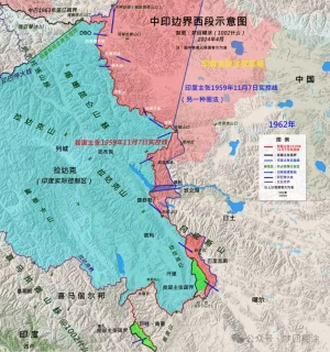
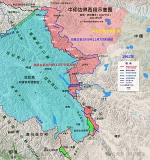
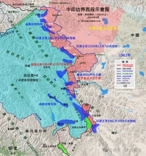
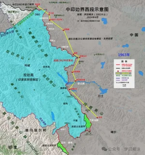
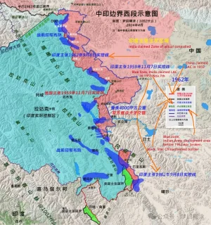
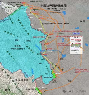
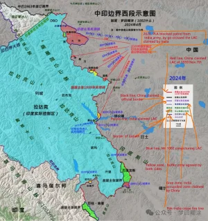
I tried put some English explanations on Mr 1002 maps.


1962, Pre-war

00003.jpg

1963, after war

00004.jpg


2024, before the agreement

00001.jpg


2024, after the agreement

00002.jpg
 
Last edited:

Latest Replies

Featured Content

Trending Threads

Donate via Bitcoin - bc1qpc3h2l430vlfflc8w02t7qlkvltagt2y4k9dc2

qrcode
Back
Top